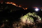
The Canyon Creek Complex Fire burns just a few miles out of John Day.
Amanda Peacher / OPB
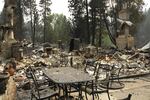


Dean Elliot stands beside the smoldering remains of his home of 53 years.
"You could have put all the water you had on this," said Elliot. "And it would have never slowed it down."
He and his wife evacuated Friday just minutes before the Canyon Creek Complex ripped down a ridge and along the creek where they lived. They took with them clothes, some photos, money and two of their three cats. They couldn't find the third cat, but they're hoping it escaped the fire.
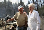
Dean and Betty Elliott look over the remains of their charred house. The Canyon Creek Fire destroyed their home of 53 years.
Amanda Peacher / OPB
Across Oregon more than 1,000 people have been forced to evacuate homes, ranches and resorts due to wildfires that blew up Friday when winds kicked up to 20 miles per hour.
The largest evacuations resulted from the County Line 2 fire on the Warm Springs Indian Reservation and the Cornet, El Dorado and Windy Ridge fires in the Baker City area.
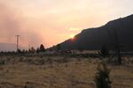
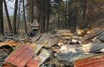
And south of John Day, the Canyon Creek Complex has grown to about 34,000 acres. More than 100 homes in the Canyon City area have been evacuated with 26 homes were lost.
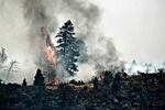
The County Line 2 fire is burning in central Oregon on the Warm Springs reservation, and has forced hundreds of people to evacuate.
Jayson Smith / The Spilyay Tymoo
The Federal Emergency Management Agency authorized the use of federal funds to help with wildfire fighting costs for the Canyon Creek Complex. FEMA funding is available to pay 75 percent of the costs associated with managing, mitigating and controlling the fire. The grants also provide reimbursement for live-saving efforts.
"Our thoughts and prayers go out to those who are displaced due to the fire," said Steve Beverlin, the forest supervisor with the Malheur National Forest in a statement.
The fire is spreading to the north down Canyon Creek toward Canyon City and John Day and to the east. About 300 federal, state and local firefighters and support personnel are now fighting the fire.
"We went from 600 acres to about 34,000 acres in a 12-hour period," said Beverlin.
National resources are stretched thin due to multiple fires in multiple states. The National Multi-Agency Group is now at its Level PL-5 for national fire preparedness, its highest point.
There are currently more than 30 large wildfires burning in Oregon and Washington.
"All of the resources are 100 percent engaged and committed on these incidents. We don’t have additional planes and helicopters to call in," said Koshare Eagle, a spokeswoman with the Northwest Interagency Coordination Center.
Eagle says there are 125 pending orders for crews that haven't been filled. She said the U.S. Department of Defense is training 200 soldiers to add to the ranks firefighters nationwide.
"It's going to take type one hotshot crews and hand crews to put it out," said Beverlin, about the Canyon Creek Complex. "We've put in for many crews, additional engines, additional aerial resources. But we plan our attacks and strategy based on the resources that we have."
Gov. Kate Brown invoked the Emergency Conflagration Act in response to the Canyon Creek Complex Friday. That allows the state to send in teams from the Oregon Office of the State Fire Marshal to help local crews battling the blaze.
Highway 395 is closed from milepost 25 to milepost 0 and is expected to remain closed for at least three days due to wildfires.
The Red Cross has set up a shelter at a community center in nearby Mount Vernon. The Grant County Fairgrounds are serving as a shelter for livestock, and several individuals have also offered their private land to shelter livestock.
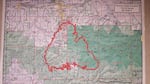
A map showing the extent of the Canyon Creek fire Saturday August 15.
Malheur National Forest