
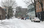
Downtown Portland in a dusting of snow, Feb. 12, 2021.
Conrad Wilson / OPB
Forecasters expect colder temperatures as a series of fronts continue to move through the Willamette Valley over Christmas weekend.
Southwest Washington will probably see snow as early as Friday night, according to National Weather Service forecaster Daniel Hartsock. The storm is expected to spread south through Portland, Salem, and Eugene. Central Oregon has a 90% chance of snow Friday night. Hartsock says snow in the Willamette Valley is most likely later Saturday evening.
“We’re looking at 24-hour periods of 1 to 4 inches possible, depending on how heavy the shower will be. For the most part, it won’t come all in one big dump, but gradually,” Hartsock said.
There is still uncertainty in relation to total snowfall amounts later this weekend, but model ensembles can give us an idea of possible ranges. Possible snow may not be how much snow we actually get, but better chance that it falls somewhere in this range than outside of it. pic.twitter.com/ViY0HgtWga
— NWS Portland (@NWSPortland) December 23, 2021
Oregon Department of Transportation spokesperson Don Hamilton said crews are ready. Their focus is on major roads, such as Interstate Highways 5, 84, 405 and 205.
He noted that ODOT uses four primary tools for winter maintenance: Plows, sand, salt and de-icer. The de-icer is the one thing they can use before the forecast, but they have to be careful because if it rains it washes the de-icer off the road. Winter maintenance, Hamilton said, is part art, part science.
“It’s all about finding the right tool to use at the right time in the right place,” Hamilton said.
He asked drivers to be patient and use caution when navigating wintry conditions. ODOT urges travelers to monitor real time road conditions on tripcheck.com.