
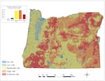
The Oregon Wildfire Risk Explorer map, created by Oregon State University as part of a new wildfire policy directed by Senate Bill 762, outlines wildfire risk at the property ownership level across the state.
Oregon Wildfire Risk Explorer
Oregon’s new wildfire risk map was taking a long time to load on Thursday as people across the state searched their addresses to find out whether their homes were in the red.
The Oregon Wildfire Risk Explorer places every single tax lot in Oregon in a risk category ranging from zero to extreme.
Large stretches of Central, Eastern and Southern Oregon landed in the red “extreme” wildfire risk category based on weather, climate topography, vegetation and nearby buildings.
About half of the 1.8 million tax lots in the state are now categorized as being part of the “wildland-urban interface,” also known as WUI. It’s a designation for homes and communities that are more vulnerable to wildfire because they are intermingled with forestland and wilderness areas.
Jackson County Fire Chief Bob Horton said the map will be helpful for identifying where to focus fire prevention work in Southern Oregon, where fire risk is very high in a lot of communities.
“The new map gives us granularity to explore the risk levels at neighborhood levels, at parcel levels, where prior to this we didn’t have the scientific backing to it,” Horton said. “We had hunches on where we thought the higher risk areas were.”
The map also could have expensive consequences for some property owners and developers because the state is also crafting new building codes and zoning requirements to help protect homes in high fire risk areas.
The new rules are still in the works and won’t be approved until later this year, but they will apply to about 120,000 properties — about 8% of all tax lots statewide — that are both inside the wildland-urban interface and labeled as having high or extreme fire risk. There is an appeal process for property owners who want to challenge the state’s wildfire risk classification of their tax lot.
The mapping process stems from a sweeping wildfire preparedness package lawmakers passed last year in response to the wildfires that burned 4,000 homes and more than a million acres of Oregon in 2020.
Defensible space
Democratic state Sen. Jeff Golden of Ashland, who led the effort to pass that legislation, said there is state funding to help property owners comply with new requirements to clear defensible space around homes in high fire risk areas and use fire-resistant materials for new construction.
“I really understand that people would be anxious about this,” he said. “We now have to live differently with wildfire. We were shown really clearly what the future looks like in the last couple of years and … lot of people were badly hurt, but we survived.”
Now, he said, the state has a chance to prepare for future fires and better protect homes and communities.
“A whole lot of the most important work is relatively easy and relatively inexpensive,” he said.
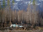
Mary Bradshaw's fire-hardened home in Elkhorn, Oregon, on Feb. 26, 2021. It was one of few that survived the Beachie Creek fire in the area likely because it was built using fire-resistant materials and had no vegetation around the house.
Kristyna Wentz-Graff / OPB
Some of the protective measures that experts recommend are cleaning out gutters, cutting lower limbs off trees and removing invasive species from around the home, like blackberry bushes.
The Oregon State Fire Marshal and the Oregon Department of Consumer and Business Services are developing rules for clearing defensible space around homes and applying wildfire hazard building code standards. The new wildfire risk map will determine where the upcoming rules will apply.
Brian Mulhollen, a property owner in Gold Hill in Southern Oregon, said he expected his home to be in the “extreme risk” category. He’s seen several wildfires near his property in recent years.
“Most of Southern Oregon, especially the Rogue Valley, is extreme,” he said.
As a former battalion chief for a firefighting unit and current manager of a helicopter company that helps fight fires, Mulhollen said he knew his home needs at least 100 feet of defensible space around it that is cleared of flammable vegetation.
But he worries about other homeowners who suddenly find themselves in the extreme fire risk category on the map.
“Most property owners don’t know what to do with that,” he said.
Mulhollen had help preparing his property for fire season from the Wildfire Protection Corps, a youth training group that has been deployed to limb trees and remove brush that could spread wildfires to people’s homes.
He said the state needed the push from Legislature to help property owners prepare.
“Oregon is way behind on wildfire risk analysis compared with other fire-prone Western states,” he said.
Insurance costs
Some property owners worried that the new risk assessment would affect their homeowner’s insurance.
Last month, Portland resident Dwayne Canfield got a letter from the insurance company that had been covering his vacation rental house in Sisters.
“They sent us a non-renewal notice saying we decided not to renew this policy because of the wildfire risk in the area,” he said. “I was shocked. We have seen fires within a mile and a half of here, but I didn’t see it as a huge risk. We’re four blocks from the city center.”
Canfield was able to find another insurance provider without spending more money on a policy, but he expects to see more homeowners in the same situation he faced now that the state has put every property into a risk category.
Kenton Brine, president of the Northwest Insurance Council, said insurance companies across the region are already doing their own wildfire risk mapping, so a risk map from the state of Oregon won’t necessarily make a big difference in their policy decisions.
“It won’t come as a surprise to insurance companies that there is wildfire risk in those red areas,” he said.
As wildfire risk is growing in the region, Brine said some insurance companies are changing their approach.
“We have seen insurers who have changed their risk appetite — even prior to the massive Labor Day fires in Oregon,” he said.
Brine said most homeowners should have no problem finding some insurance for their homes even in extreme fire risk areas.
Golden said he and officials with the Oregon Department of Forestry have been talking with Oregon Insurance Commissioner Andrew Stolfi about the effects wildfire risk mapping could have on people’s insurance policies.
“That is a real thing. We’re going to have to be looking at that,” he said. “The wildfires in the West, all over the West, not just Oregon have become a hazard. That really turns the insurance market upside down.”
Bradley Parks contributed reporting from Bend.