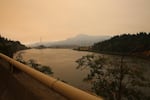
Smoke from the Eagle Creek Fire fills the air near the Bonneville Dam along I-84 on Sept. 14, 2017.
Ericka Cruz Guevarra / OPB
Rainfall across western Oregon could oust some of the state's more than two dozen wildfires this week. But trouble still looms in the form of landslides and a possible dry-out.
The Oregon State Fire Marshal’s Office says the Eagle Creek Fire is slowly growing on the southern and western edges of the fire.
As of Saturday, the fire in the Columbia River Gorge was burning more than 45,000 acres and was 32 percent contained. The fire ignited Sept. 2 and was human-caused, according to Oregon State Police.
While fire crews anticipated significant rainfall beginning Saturday evening to help with suppression efforts, they’re concerned for landslides.
Related: Winter Rains Could Lead To More I-84 Closures After Eagle Creek Fire
Ali Ryan Hansen with the Oregon Department of Geology said the Columbia River Gorge is already susceptible to landslides. Add in burned trees and brush, and the sudden onslaught of rain and the threat of landslides intensifies.
"As we enter the rainy season, because burned areas have been added to that already steep terrain and weak geologic material, we really need to be aware of the landslide hazard," she said.
Areas of concern in the Gorge and surrounding areas, according to Hansen, include Government Camp, Corbett, Multnomah Falls, Rooster Rock, Cascade Locks, Hood River, North Bonneville, Stevenson and Carson. Other notable areas of concern outside of the Gorge include Detroit and Santiam Pass.
The Oregon Department of Geology offers tips on staying safe during landslide warnings on its website.
The Oregon Department of Transportation said it will be assessing the threat of landslides to area roads in months to come.
The National Weather Service is forecasting between 3 to 5 inches of rain, specifically on the fire, through Thursday.
“We’ve got one more day of fire season, in my opinion,” said Shawn Weagle, National Weather Service Meteorologist at a Hood River community fire briefing Saturday.
Fires burning further south like the Whitewater Fire and Chetco Bar Fire (the nation's largest, burning 188,000 acres as of Saturday) will also see wetting rains.
"This rain will put a damper on the majority of fires in our forecast area," said Shad Keene, a meteorologist with the NWS in Medford, Oregon.
The Chetco Bar Fire region should see more than an inch of rain in the coming days; the Umpqua North and High Cascades complexes about 2 inches.
But that may not be enough to call it an end to fire season in southwest Oregon just yet. A "season-ending event" for wildfire is multiple days of wetting rains over the fire area.
Keene said northeast winds after this week's rain could dry out parts of southwest Oregon, keeping them prone to fire.
"We're unlikely to get back to where we were earlier [this summer] with long, hot days," Keene said. But hot, dry conditions are not out of the question for that part of the state this time of year. Medford has record highs in the triple-digits well into September.
Still, Keene said, southwest Oregon fire "activity will be sharply reduced" after rains this week.
OPB's Amanda Peacher contributed reporting to this story.