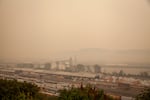
The air quality in Portland, Ore., has at times ranked the worst of all major cities in the world due to smoke blowing in from several surrounding wildfires.
Claudia Meza
Parts of Oregon could see some relief from wildfire smoke due to incoming rain starting later Thursday.
David Bishop with the National Weather Service in Portland said the Willamette Valley should expect to see anywhere from two-tenths to four-tenths of an inch of rain. That could go up to a half-inch for the Cascades and the Coast Range.
That precipitation should help improve air quality, which has been rated as hazardous for much of the state for about a week.
The precipitation will specifically cause a “mixing of the atmosphere,” Bishop said.
“That will bring some of the cleaner air that’s up above say 3,500 feet or so, and that will allow some of this ground junk, smoke, particulate matter, that will enable it to mix out, and just kind of clean the air out a little bit,” he said.
NWS can’t specify exactly how much the air quality should improve, but Bishop said, within the next three days or so, “the general trend in improvement should be notifiable.”
Gabriela Goldfarb with the Oregon Health Authority said Thursday that her agency is also expecting to see improving air quality.
“People along the coast are already seeing good air quality,” Goldfarb said. “We are optimistic that smoke in the rest of western Oregon will clear by the middle of the day Friday. Central Oregon skies will clear over the course of Friday and Saturday.”
Goldfarb said that may not be the case for areas close to currently burning fires.
“The smoke can be unpredictable with these fires still on the landscape,” she said.
Along with the precipitation, there is a chance of thunderstorms starting late Thursday afternoon and continuing into early Friday morning for Northwest Oregon. According to NWS outposts located in Medford and Pendleton, there is also a chance of thunderstorms for the rest of the state as well.
“With thunder, obviously there is lightning potential,” Bishop said.
Many of the larger fires currently burning in Oregon, which have contributed to more than 1 million acres burned across the state, were originally started by lightning strikes last month. Because these potential lightning strikes will be accompanied by precipitation, that moisture should help stifle any potential concern for more fires, Bishop said.
“We can’t say, 100% sure, that nothing will happen if there’s a potential lightning strike, but precipitation will mitigate some of those possibilities,” he said.
One downside of incoming precipitation for the region could be the potential for flash floods. Bishop said there are two flash flood watches in effect for areas around the Riverside and Beachie Creek fires, spanning areas of Clackamas County and east of Salem, and the Holiday Farm Fire, east of Eugene.
“We don’t know what the ground situation looks like for those areas. There haven’t been those people who have the expertise in understanding the soil makeup and the ecology of that,” Bishop cited as the reason for the watches. “We just want people to be aware and overly cautious in those areas because if there is a flash flood, the likelihood of debris flows and things like that are very, very high.”
According to NWS in Medford, similar flash flood watches have also been issued for the areas near the Archie Creek Fire and Thielsen Fire, both burning east of Roseburg.
The Oregon Department of Geology and Mineral Industries is also telling people to stay alert for potential landslides in the Cascade foothills.
“Heavy rain can trigger landslides, rockfall and debris flows in steep terrain, and the risk is higher in burn areas,” the department said.
Debris flows are “rapidly moving, extremely destructive landslides," it said. They can contain large items such as boulders and logs.
