
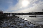
Ice forms on the Deschutes River in Bend's Old Mill district on Dec. 27, 2021.
Emily Cureton Cook / OPB
More snow is heading to the Pacific Northwest, prompting winter weather advisories from the National Weather Service, and putting road crews on high alert in mountain ranges, the Willamette Valley and along the Oregon coast.
In the Portland metro area and the Willamette Valley, 1 to 3 inches of snow is expected to accumulate with most of the snow falling late Monday and early Tuesday morning.
Related: Find details about closures in the Portland area and the Willamette Valley.
“With freezing temperatures going on tonight and in the morning, we are in particular, concerned about the chance of black ice and other icy conditions around the city,” Hannah Schafer of the Portland Bureau of Transportation told the Associated Press. “Where we treat our roads, on our designated snow and ice routes, we anticipate that it will be easier to travel.”
The agency is urging people to stay home if they don’t have to travel, to keep clear for emergency vehicles and buses.
Forecasts say 1-2 inches accumulation is possible overnight Monday into Tuesday in Southwest Washington. The heaviest snow is expected to fall between 6 p.m. Monday and 4 p.m. Tuesday.
The Oregon Department of Transportation warned that Monday’s evening commute would be snarled by slippery roads and fresh snow across Southwest Washington and Northwest Oregon and that traffic problems could continue into Tuesday.
In Central and Eastern Oregon, an arctic air mass is expected to bring significantly colder temperatures starting Monday night and continuing into next weekend, according to the National Weather Service. Regions of high elevation near Oakridge and Bend had more than 48 inches of snow over the weekend. High daytime temperatures should range in the teens and 20s, with overnight lows in the single digits. Wind chills at night could range from the single digits above zero, to 10 below zero.
Statewide, just over 5,000 homes and businesses were without electricity across Oregon as of Monday evening, according to the poweroutage.us map. Power failures were dispersed across a wide swath of the state, including Douglas County in the south, Lincoln County at the Coast and Columbia County in Northwest Oregon.
Traction tires or chains are required on Oregon Highway 6 through the Coast Mountains due to snowy conditions on Dec. 27, 2021.
Oregon Department of Transportation
Temperatures will be higher along the Oregon Coast, according to the National Weather Service, but snow or snow-rain mixes are likely to continue, with new snow accumulations of 1 to 2 inches possible overnight. The snow level is expected to be at around 300 feet near the coast. Oregon Department of Transportation officials are warning travelers to plan for slippery conditions and slow travel times along the coast.
Southern Oregon forecasts call for continued snow showers Monday and Tuesday, with daytime highs in the mid-30s and overnight lows around 30 degrees in southwestern Oregon. An inch of new snow could accumulate during the day Monday, with less than an inch expected to fall overnight.

Interstate 5 is lined by snow in Southern Oregon, as seen in this webcam image taken the morning of Monday, Dec. 27, 2021.
Oregon Department of Transportation
ODOT warned that roads could be significantly affected through Jackson County, and parts of Douglas, Curry and Josephine counties, and is urging people to carry tire chains and prepare for snow-covered roads and limited visibility through Tuesday morning.
Malheur County could see accumulations of 2-4 inches of snow. Wind gusts as high as 35 mph are likely to lead to heavy snowdrifts and blowing snow near the Nevada border, transportation officials said.
In Washington, up to 6 inches of snow fell across the Seattle area. More than a foot was reported near Port Angeles across the Puget Sound on the Olympic Peninsula. Icy roads continued to make travel a challenge throughout the region.
The Associated Press contributed to this story.