
A strong cold front is expected to bring heavy rain and wind to the Pacific Northwest starting Sunday night.
The National Weather Service issued a flood watch from Sunday night through Monday afternoon for the Portland Metro area down through the Willamette Valley, as well as much of the coast.
There’s also a wind advisory in place for much of Oregon, with stronger winds predicted in the lower Willamette Valley and Central Oregon. These winds could break tree limbs or cause power outages.
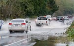
Flooding along Hwy 18 near Otis, Nov. 12, 2021.
Kristyna Wentz-Graff / OPB
This storm is expected to stick around for the next few days.
“While confidence is high it will be a wet and stormy week, the details of the rainfall timing and amounts and the specifics of which watersheds will be most affects remains uncertain,” reads a report from the NWS Portland office.
People in high-wind areas should secure anything outside that could become hazardous. They should drive carefully, especially if they’re driving a large vehicle.
Meanwhile, the Cascades are expecting to get another 15 to 30 inches of snow at elevations above 2,000 feet. The weather service advises people to avoid traveling through this region, if possible.
Expect heavy snow today and tonight in the Cascades and Hood River Valley. Visit https://t.co/uYjtSFHLqr for forecast specifics and https://t.co/ZFDcmqTCwS or https://t.co/gggY2MEQTK for road conditions. #wawx #orwx #snow #pdxtst pic.twitter.com/NXvDI4nToK
— NWS Portland (@NWSPortland) January 2, 2022