
The National Weather Service expects cloud cover to reduce the further south and east Saturday's eclipse travels over Oregon.
National Weather Service
The weather forecast for Saturday’s solar eclipse over Oregon has improved over the last few days.
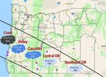
The celestial phenomenon starts along Oregon’s South Coast around 8:04 on Saturday morning, above Coos Bay. The “ring of fire” effect — the peak of the moon’s coverage of the sun— occurs about 9:18 a.m. on the coast. The trouble is the local forecast is mostly cloudy, leaving about 70% of the sky covered in clouds and maybe some drizzle.
But David Bishop, with the National Weather Service, predicts the chances of blue sky increase as you travel inland.
“The farther east and the farther south you go will give you a higher probability of experiencing clear skies,” he said. “In general, what you can expect is to see more blue sky, rather than clouds.”
By Crater Lake, for example, it’ll be mostly clear with only about 15% of the sky covered.
“The reason why there’s been a significant change in the forecast is the system that we are expecting to bring in all of these clouds and precipitation, has slowed down,” Bishop said Friday.
That system is expected to bring rain by Saturday afternoon.
While forest fires and massive traffic jams predicted during 2017′s eclipse didn’t materialize — authorities are still asking people to be courteous, carry provisions, and fill up the car. Rural gas stations in the eclipse path can be far and few between.