
Sticking snow is a strong possibility Tuesday night into Wednesday morning at low elevations in the Portland metro area, according to the National Weather Service.
Forecasters say the most likely scenario is between a half-inch and an inch of snow accumulating between 10 p.m. Tuesday and 10 a.m. Wednesday, But there’s a chance lowland areas in northwest Oregon and Southwest Washington could see more than an inch.
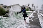
Katarina Bush, 9, throws a handful of snow while heading out on a walk in Northeast Portland on Jan. 14, 2024. Similarly, snow could stick on the valley floor in the Portland metro area overnight, a year later in February 2025.
Kristyna Wentz-Graff / OPB
“The Cascades will also see stronger accumulations from Tuesday night into Wednesday, with guidance suggesting a 60-80% chance for 6 inches or more of snow,” the area forecast discussion stated Tuesday morning.
The National Weather Service has issued a winter weather advisory from midnight Tuesday to Wednesday at noon for much of northwest Oregon and Southwest Washington.
Multnomah County announced it would be declaring an emergency due to the potential snow and opening severe weather emergency shelters Tuesday evening.
Find severe weather resources in Multnomah County
Washington County is also opening additional severe weather shelters starting Tuesday at 2 p.m. And overnight shelters will be open in Clark County and Clackamas County.
Drivers should keep in mind that the overnight snow could impact the Wednesday morning commute. But the temperature is expected to rise into the 40s by Wednesday afternoon, and precipitation should become all rain after 1 p.m. Wednesday.
Little or no snow is expected to fall in the metro area Wednesday or Thursday night.
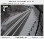
In this image captured by an Oregon Dept. of Transportation camera just after 8:30 a.m. on Feb. 4, U.S. 101 at Seaside along the Oregon Coast is mostly covered with snow. Its elevation is 13 feet.
Courtesy of Oregon Dept. of Transportation
A winter weather advisory remained in effect Tuesday morning for snow accumulating in the north Oregon Coast Range lowlands, the south Washington Coast, and the Willapa and Wahkiakum Lowlands. Weather conditions in those areas led to several school closures and delays. That weather advisory was set to expire at 1 p.m. Tuesday.
A winter weather advisory was also effect Tuesday for Central Oregon, the John Day Basin, and the foothills of Oregon’s southern Blue Mountains. NWS warns that a lull in precipitation Tuesday morning could give way to snowfall rates as heavy as 1 inch per hour Tuesday afternoon and night.
Travel could be difficult due in those areas during the Tuesday evening commute. That advisory expires at 10 a.m. Wednesday.