
Winter weather alerts remain in place for several inches of snow along the Oregon Coast Range and the Cascades Wednesday.
Along the Willamette Valley, a winter weather advisory for accumulating snow expired Wednesday morning. But snow flurries did fall in much of the Portland metro area.
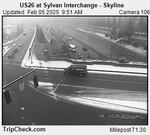
In this image captured by an Oregon Dept. of Transportation camera just before 10 a.m. on Feb. 5, a light dusting of snow has fallen along U.S. 26.
Oregon Dept. of Transportation
Temperatures were mostly above freezing in and around the city, and there was no sign of sticking snow Wednesday. Still, traffic officials warned that roadways, especially on bridges and overpasses, could become slick and hazardous.
Several schools, offices and organizations in the area closed or delayed their openings Wednesday morning. That included the city of Vancouver’s municipal offices.
Check the latest delays and closures
The temperature throughout much of western Oregon had risen well above freezing by early afternoon.
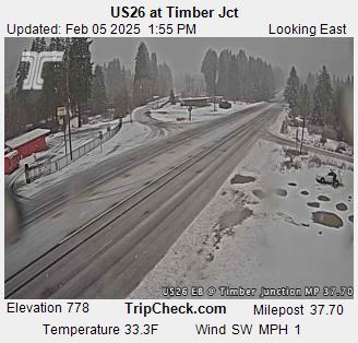
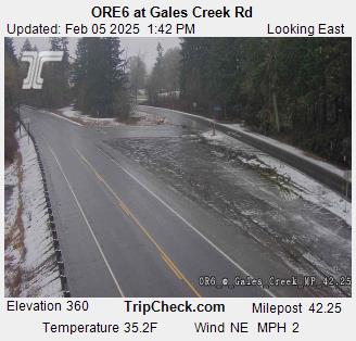
In the Coast Range, a winter storm warning remained in place place through 7 p.m. Wednesday. Heavy snow fell early Wednesday morning along the Coast Range passes, including U.S. 26 at Timber Junction and Oregon 6 at Gales Creek Road.
Drivers were urged to delay travel over the Coast Range passes until weather conditions improve.
A winter weather advisory for several inches of snow along the Cascades is in effect through 4 a.m. Thursday.
Traffic officials advise drivers to have winter emergency driving kits readily available and check road conditions before heading out. For the latest road conditions and chain restrictions in Oregon, call 511, or visit TripCheck.
According to the longer-term National Weather Service forecast, temperatures throughout western Oregon will remain below normal through next week, “with additional chances for light snow showers Friday night and Saturday morning, albeit with very little to no snow accumulation.”
The area should then stay mainly dry Sunday through Tuesday. Any snow showers would likely be confined to higher elevations in the Cascades.
Some people might be a bit frustrated that they aren’t getting the same picturesque snowfall that the Cascades or Coastal Range is seeing. There are multiple factors that affect the likelihood of seeing snow accumulations at lower elevations. #ORWX #WAWX pic.twitter.com/tyPnp3laCS
— NWS Portland (@NWSPortland) February 5, 2025