A wildfire that started Wednesday afternoon near Rowena, Oregon, grew to an estimated 3,500 acres by Thursday morning.
According to the Northwest Interagency Coordination Center, the fire was human-caused. But no further details about its origin were available.
The Wasco County Sheriff’s Office has issued Level 3 Go Now evacuation orders for more than 800 people living in the area. Level 2 Be Set evacuation orders are in effect for more than 1,400 people. And more than 1,500 people are under Level 1 Get Ready evacuations.
According to the sheriff’s office, no deaths have been reported.
More than 2,000 homes were threatened and 20 had been destroyed as of Thursday morning.
Check the latest evacuation maps here
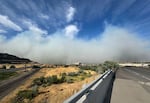
Smoke from the Rowena Fire spreads across the freeway, seen from the River Road ramp to I-84 westbound near the Dalles Dam, June 11, 2025.
Tony Schick / OPB
Oregon Gov. Tina Kotek invoked the Emergency Conflagration Act on Wednesday to help deploy additional resources for crews battling the fire.
On Thursday, fire officials from multiple agencies spoke with reporters at a press conference in The Dalles about the early-season wildfire.
Travis Medema with the Oregon State Fire Marshal said this year’s fire season is ahead of schedule.
“We’re seeing conditions that are at least two weeks, maybe three weeks ahead of where they were last year,” Medema said. “Last year, for folks that were in Oregon will remember, 1.9 million acres burned in this great state, a record in recent history.”
Thursday afternoon, NWCC listed 78 personnel fighting the fire, and its perimeter was listed at 0% contained.
A Red Cross emergency shelter was set up at The Dalles Middle School, at 1100 E. 12th St.
Rebecca Marshall with the Red Cross said 45 people stayed at the shelter on Wednesday night.
“Right now we’re in a precarious situation because we have a lot of homes at a Level 2 evacuation,” she said. “And with this wind blowing, we just don’t know where it’s going to go from here.”
The Wasco County Fairgrounds, in Tygh Valley, is open for livestock, horses and people with trailers.
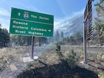
Smoke from the Rowena Fire, seen from Interstate 84, on June 12, 2025.
Kristian Foden-Vencil / OPB
Interstate 84 was closed through the area for much of the day Wednesday, but has since reopened. Closures are still in place for Highway 30.
Check the latest traffic updates
The Wasco County Sheriff’s Office received reports Thursday morning that people were stopping on I-84 and in other unsafe areas to walk into Level 3 evacuation zones.
“For the safety of the public and first responders, we are urging folks to remain out of the evacuation zone,” the sheriff’s office warned in a statement. “It is extremely dangerous and may impact resources working to save property in the area.”
Elsewhere in Oregon, the Ferry Fire was burning about 2,500 acres in grass and brush near the Cottonwood Canyon State Park, on the John Day River.
The fire reached Highway 206 Thursday afternoon and burned through the state park. No evacuations were listed in Gilliam County, but notices have been issued for areas north of Highway 206 in Sherman County.
On the other side of the Columbia River, two smaller wildfires started on Wednesday and closed Washington State Route 14. That road also reopened by Thursday morning.
The Grant Lake Fire and the Sand Hill/Hot Springs Fire, both near Carson, Washington, were burning a total of less than 50 acres as of Thursday morning.
Resources: Stay safe and informed during wildfire season with OPB’s wildfire guide at opb.org/wildfires. This resource offers essential safety tips and preparedness guidance to help you navigate fire and smoke events. This resource was created as part of our commitment to serving the public as wildfire seasons become longer and more dangerous.