
Bill and Denise Lakey fill sandbags at the Clackamas Fire Station in Milwaukie. They live next to a steep road that funnels water down their driveway and into their garage. Dec. 18, 2025
Kristian Foden-Vencil / OPB
Officials are warning residents in northwest Oregon and Southwest Washington to once again brace for more rain and strong winds on Thursday.
An atmospheric river is making its way through the region, bringing with it several weather hazards, including potential flooding and increased landslide risks.
In response to the severe weather, the Oregon Department of Emergency Management activated the State Emergency Coordination Center to Level 3 on Wednesday. The activation allows the state to provide speedy support to local emergency management offices and communities impacted by the atmospheric river.
The Clackamas River near Estacada is expected to reach major flood stage tonight into early Friday morning. Stay away from parks along the river and do not drive into flooded areas. #orwx #pdxtst pic.twitter.com/4tYqT0htUT
— NWS Portland (@NWSPortland) December 18, 2025
The National Weather Service has issued major flood warnings for several rivers in Oregon and Washington including the Clackamas River at Estacada, the Hood River near Tucker Bridge and parts of the Cowlitz River.
According to the NWS, the Clackamas River near Estacada is expected to rise above flood stage this evening and crest around 25 feet late tonight.
Officials are warning people to stay away from parks along rivers as well as any other low-lying, flood prone areas.
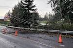
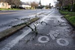
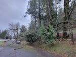
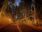
Officials with the Oregon Department of Transportation are also urging drivers to take extra precautions when traveling Thursday and Friday. Multiple roads have closed across Oregon due to high water and downed power lines on roadways.
High winds and wet soil
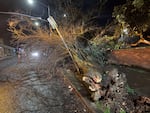
High winds early Wednesday morning knocked down power lines and trees throughout the region. At one point, more than 560,000 people were without power.
Tualatin Valley Fire & Rescue crews had to respond to nearly 90 calls for service between midnight and 8 p.m. That included an incident in West Linn where downed trees and power lines trapped a student and a driver in a school bus.
“Our firefighters coordinated with the school district and Portland General Electric to keep the driver and student safe until utility crews could deenergize the lines,” TVF&R said in a Facebook post. “A parent of the student was also able to come to the scene to help keep their child remain calm and assured. In the end the driver and student were able to safely exit with no injuries.”
TVF&R officials shared the following reminders:
- Never touch a downed power line — or anything else the line is touching
- Always assume power lines are live and stay at least 50 feet away
- Remember, a downed line doesn’t have to spark to be dangerous
According to NWS, soil in the area is generally still saturated from last week’s storms, so it doesn’t take exceptional wind speeds to knock down trees or power lines.
And in recent days the strong winds have been moving abnormally south to southwesterly, so that also makes tree damage more likely.
More flooding and wind in the forecast
Steady rain from this week’s second weather system began to fall early Thursday morning. It’s expected to continue throughout the day, with the heaviest rain expected in the afternoon and evening.
🌧️ A strong atmospheric river will bring heavy rain and widespread river flooding across northwest Oregon and southwest Washington on Thursday. Some rivers may continue to flood through at least Saturday. If you live in a flood-prone area, have a plan ready! #ORwx #WAwx pic.twitter.com/aBzPTI3vyI
— NWS Portland (@NWSPortland) December 17, 2025
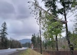
The weather service has also issued a wind advisory for much of western Oregon including the greater Portland-Vancouver metro area.
According to the NWS, people should expect to see winds of up to 20 miles per hour — with gusts up to 45 miles per hour — throughout the day.
The strong winds could knock down trees and power lines, which may result in widespread power outages.
Officials are reminding people to secure any objects that could easily blow away and to stay away from any downed power lines. That advisory is in effect until 7 p.m. Thursday.
A high wind watch is also in effect for the Central Oregon Coast Range, where gusts could reach up to 60 mph.
Preparing for flooding

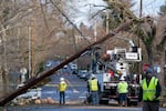
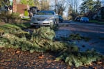
A car is crushed by a fallen tree on Northeast 24th Avenue on Wednesday, Dec. 17., 2025 in Portland.
Saskia Hatvany / OPB


Due to the potential for flooding along the Clackamas and Sandy rivers, a spot outside the Clackamas Fire Station in Milwaukie was set up as a sandbagging location.
James Augustus was there Thursday morning, filling 30 sandbags for people living along Kellogg Creek.
“I’m just trying to keep the water away from the foundations of the houses,” he said.
Retired welder Bill Lakey lives next to a steep road that funnels water into his garage.
“Everything runs down the road and ends up running down our driveway,” Lakey said. “So I’m getting a few bags to block the front of my garage.”
Lakey said that it’s not just a question of filling a few sandbags and stacking them. There are also few tricks. First, don’t fill them completely.
“Make them about half-full. That way the sand will spread out when you lay it down,” he said. That makes the barrier more efficient at deflecting water.
For the best longevity, the sandbags should also be stacked in a staggered pattern, usually no more than three layers high.
“I just stack them like bricks,” Augustus explained.
And the last trick is to ensure the open and folded end of the sandbag faces downstream, against the water flow. That helps to ensure the sand doesn’t get washed out of the bag.
Sandbags work best at deflecting moving water, they’re not going to be waterproof.
The Portland metro area has several free, self-serve sandbag stations. Most sites are open 24/7 and while bags are usually provided, people should bring their own shovels and expect to do the work.
Key locations in the metro area include: Lents Park and Gabriel Park in Portland, 2123 Hogan Road in Gresham, Hillendale Park in Oregon City and the Wilsonville Transit Center at SW Barber Street.
Check more locations in the Portland metro area
In Clackamas County, authorities have activated their emergency center.
Spokesperson Scott Anderson says the county wants people to be aware of rising rivers like Johnson Creek and the Clackamas and Sandy rivers, but to not call 911 unless there’s an immediate threat to life or safety.
Check the latest emergency closures and delays at opb.org/closures