

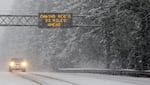
This image from the Oregon Dept. of Transportation shows U.S. 26 covered with snow at Blue Box Pass Summit on Wednesday, Jan. 7, 2026
Oregon Dept. of Transportation
A winter storm could bring another 2 feet of snow to Cascade mountain passes by early Thursday, and it could bring thunderstorms and hail to northwestern Oregon Wednesday afternoon.
A winter storm warning remains in effect through Thursday afternoon along most of the Washington and Oregon Cascade range, and in northeast Oregon’s Blue Mountains.
The National Weather Service warns that roads will be slick and hazardous, especially bridges and overpasses. Wind gusts along the mountain passes could be as high as 45 mph.
More than a foot of snow had already fallen along the passes by Wednesday morning, after an earlier weather system moved through on Tuesday.
Officials are urging people to postpone travel until weather conditions improve.
At lower elevations between the coast and the Cascades, heavy rain could lead to reduced visibility at times through Thursday.
“Another potential impact from this frontal system today will be from thunderstorms,” according to NWS meteorologists. “There is a 15-20% chance for thunderstorms across the entire area, mainly between 10 a.m. and 10 p.m. Wednesday, with the highest chances along the coast.
“Any passing thunderstorms may result in lightning, heavy rain, gusty erratic winds with gusts up to 40 mph, and/or small hail.”
FILE - Travel over the mountain passes in Oregon could become more treacherous by early Thursday as more than 2 feet of snow could fall at higher elevations. Officials are urging people to postpone travel until weather conditions improve.
Anna Reed / Statesman Journal
Forecasters said there was a very small chance of snow falling at much lower elevations by Thursday morning, but with little impact expected.
“Though this is very unlikely, a heavy shower could drop snow levels down to the valley floor and bring at least a rain/snow mix,” the National Weather Service area forecast discussion reads. “Rest assured that impacts from snow are not expected in the lowlands given the more mild temperatures/onshore flow. Any snow that falls would melt very quickly.”
Calmer weather is expected throughout the region beginning on Friday, with possible light rain during the weekend, according to the weather service.
Related: Preparing your car for a winter storm