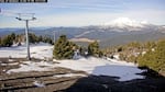
FILE - A screenshot from a Mt. Bachelor webcam on Dec. 11, 2025, shows minimal snow.
Courtesy of Mt. Bachelor website
Unusually warm temperatures, dry conditions and a lack of storms have all led to a mid-winter dry spell in Oregon and Washington.
With no significant rainfall or weather systems expected across the state for at least the next couple of weeks, officials fear this dry spell could worsen the state’s snowpack.
“We might get a little bit of rain, and a little bit of snow up in the mountains, but it’s not going to be enough to be the miracle we need to save the snow season,” said Larry O’Neill, Oregon’s state climatologist. “Right now, the snowpack is one of the worst that we’ve had since 1981.”
According to O’Neill, this year’s snowpack is worse than in 2015, when more than 80% of the region’s snow measurement sites, which included the entire West Coast and parts of Nevada and Idaho, showed record-low snowpack levels.
Back then, as now, warmer temperatures combined with little rainfall led to a lack of snow. As of Thursday, Oregon’s snowpack was at 33% of normal.
David Bishop is a meteorologist with the National Weather Service in Portland. He said conditions so far this month have been on the drier and warmer side of things.
According to Bishop, rainfall measurements recorded at Portland International Airport from Jan. 1 through Jan. 20 showed the area had received 2.13 inches of rain, compared to the normal value for the month of 3.34 inches.
The Northwest was hit with back-to-back atmospheric rivers in December. But O’Neill said those storms brought a lot of heat with them. Because of that, all the precipitation the state received during those storms fell as rain rather than snow.
Many Northwest ski resorts have delayed or suspended their skiing operations due to a snow shortage.
Why it’s so dry
While dry spells during mid-winter aren’t unusual, O’Neill said what stands out the most about this one is how long it’s been going on.
Part of it has to do with a lack of storms, but it’s mainly due to a long-lasting polar vortex in the eastern part of the country.
An updated Day 3-7 Hazards Outlook has been issued. https://t.co/VBxTZCp4sE pic.twitter.com/SxdSE9l16F
— NWS Weather Prediction Center (@NWSWPC) January 22, 2026
“When we have the polar vortex out east, the Pacific Northwest will have this big high pressure system that just sits right over the top of us. And that high pressure system will divert storms away from us,” he said. “It’ll divert the storms into Alaska, sometimes down in California, and kind of leave us high and dry.”
Potential impacts
Looking ahead, the bad winter snowpack could also lead to bad spring stream flows, a drier summer and possibly an earlier, more intense wildfire season.
“It has a wide-ranging effect from loss of recreation, water shortages, and it’s also a stressor for fish in the rivers and streams,” O’Neill said. “And then the lack of moist landscape too. If this trend continues through the rest of the winter and into spring, we could really expect that there’ll be increased wildfire risk because the higher elevations that are more prone to wildfires will dry out faster.”
He said other potential impacts could include limited irrigation for crops during the growing season and less water for hydroelectric power generation, which could possibly increase electricity prices.
It could also affect summertime tourism and recreation.
Rain could be on the way
According to O’Neill, Oregon has historically seen very wet, rainy conditions during February and March that have made up for the winter’s dry start.
“We’re expecting that there will be another, pretty good, wet period sometime in the middle to end of February,” O’Neill said. “But right now, it remains to be seen whether that will be the key series of storms that we do need to save the winter.”
NWS forecasts: Medford | Pendleton | Portland | Vancouver