
Oregon is in the middle of a record-breaking snow drought for this time of year.
If conditions don’t change, it could spell a challenging year ahead for cities, aquatic wildlife, outdoor recreation, farming, hydropower facilities, and, possibly, a longer-lasting wildfire season.
An unusually warm, sunny and dry winter has brought with it little snow across much of the Pacific Northwest.

Mount Hood snowpack on Dec. 12, 2025.
Saskia Hatvany / OPB
While Washington and Idaho are struggling, they appear to be in better shape than Oregon.
Those two states have reported warmer winter temperatures with some rain and some slightly better snowpack conditions toward their northern borders, whereas a mid-winter dry spell continues to loom across much of Oregon.
Oregon’s current statewide average snowpack – measured by how much water is trapped in the snow – is its lowest on record, at 2.9 inches. That’s nearly 30% lower than the previous record-breaking low snowpack in 2015.
Historically, January is a significant month for snow accumulation in much of the Pacific Northwest. This January, that didn’t happen.
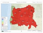
A U.S. Department of Agriculture map of snow drought in the West as of Feb. 11, 2026.
Map via U.S. Department of Agriculture Natural Resources Conservation Service
And now, the chances of recovery are low, said Larry O’Neill, Oregon’s state climatologist.
“Our snowpack is doing really poorly, and at this point in time, a big recovery in the snowpack is really not likely based on historical conditions of the typical amount of snow we get between now and the end of the snow season – typically around April 1,” he said.
Scientists attribute snow drought conditions to climate change, primarily caused by humans burning fossil fuels. O’Neill said it’s harder to say this year’s weather conditions were solely caused by climate change, but the warmer, drier winter does reveal something.
“This one winter doesn’t necessarily tell us it was caused by climate change,” he said. “But we know that the winters in the coming decades are going to be much more like this. And I think the story here is to look at how impactful these conditions are to us, because we know we’re going to expect them more in the future.”
Uncertain summer conditions
The last time Oregon had a record low snowpack, in 2015, the entire state was either under severe or extreme drought conditions toward the latter half of the summer, and 25 out of the state’s 36 counties had declared a drought of emergency. At one point that year, Oregon became the nation’s No. 1 wildfire priority.
By then, many farmers and ranchers across Central and Eastern Oregon had already been dealing with multi-year droughts and low streamflow for irrigation.

FILE - Poor snowpack covers Mount Hood on a warmer-than-average day. Temperatures reached 56 degrees Fahrenheit in Portland, Ore., on Feb. 3, 2026.
Eli Imadali / OPB
Josh Bailey, the general manager at the North Unit Irrigation District in Central Oregon – one of the largest irrigation districts in the state – said he’s optimistic the region could still see some good snowpack buildup before the irrigation season begins.
“However, if we don’t, we can expect another year of subpar [water] allotments for district patrons,” Bailey said. “I don’t have any expectations of what that will be, as a lot can change between now and April 1.”
Farmers and ranchers have not received a full allotment of water since 2018 in that district.
Bailey does point at one bright spot, the Wickiup Reservoir – which supplies water to the district – is currently 83% full.
“This is beneficial, but it’s important to understand how the Cascade system operates: there is roughly a nine-month delay in the effects of water levels,” he said. “This means that the water availability we see now is a result of last year’s snowpack. If we don’t receive significant snowfall this season, it will certainly affect us this year, and we will likely experience a severe drop next season as well.”
As far as wildfire season this year, Karin Bumbaco, the deputy state climatologist for Washington, said it’s too early to tell what it will be like. It will depend on spring conditions.
“Usually when we have a low snowpack like this, and it melts out earlier than normal because it’s less-than-normal [snowpack], we just have a longer fire season,” Bumbaco said. “So once it dries out, we just have a bigger window of opportunity for fires to start.”