A winter storm brought snow to the Oregon Coast Range and Cascade mountains Wednesday night and Thursday morning.
But the Willamette Valley mostly remained above freezing through Thursday morning and didn’t see any accumulating snow.
Along the Oregon and south Washington Cascades, a winter weather advisory remains in place through 7 p.m. Timberline Lodge and Mt. Hood Meadows reported 4 new inches of snow Thursday morning, and the National Weather Service said up to 5 more inches could fall throughout the day, especially above 1,500 feet.
The winter weather advisory in the Coast Range remains in effect through noon Thursday. Several inches of snow fell overnight on the passes at higher elevations, including Oregon 6 at Lees Camp and U.S. 26 at David Douglas Park.
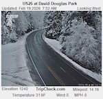
This image from an Oregon Dept. of Transportation traffic camera shows snow on U.S. 26 at David Douglas Park on Feb. 19 at 7:52 a.m.
ODOT
Several school districts started late or were closed Thursday morning.
Check the latest closures and delays
Wet roads could still be an issue as temperatures could drop again Friday morning, according to the NWS area forecast discussion.
But the forecast for the weekend is warmer and drier throughout the area.