Travel may be dangerous in parts of Oregon starting Tuesday evening.
“We do have this powerful storm system coming off the Oregon coast as we speak,” Tyree Wilde with Portland’s National Weather Service said.
Wilde said the Portland metro area isn’t expected to see any sticking snow, though it may see some rain mixed with snow.

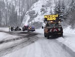
Emergency crews respond to a crash on Oregon's snowy Santiam Pass at milepost 77 in on Tuesday, Nov. 26, 2019.
Oregon DOT / Twitter
“[Portland] is too far north, we’re too far away from the storm system,” he said. “We’re going to mainly stay dry.”
Lower elevation areas around Eugene and Medford could see about an inch of snow. Other parts of Oregon could get blanketed.
The Oregon Cascade Mountain Range has already seen some snow and is expected to get more, Wilde said.
Starting Tuesday afternoon and into the night, the mountain range from Mount Hood down to around Santiam Pass should expect “about 10 to 18 inches of snow,” Wilde said. “If you go a little further south to the Lane County Cascades, so Willamette Pass, much more snow there — about one to two feet, and strong, gusty winds of 45 to 50 miles per hour.”
Mike Petrucelli with the National Weather Service in Medford said at higher elevation points in Southern Oregon, like Highway 140 heading to Klamath Falls and the Interstate 5 at Siskiyou Summit, could get up to a foot of snow.
For those areas, Petrucelli advises people to avoid driving if they can.
“Because of the active weather that’s coming in now, I’d say travel is highly not recommended, especially over the higher passes,” Mike Petrucelli with Medford’s National Weather Service said. “If they want to take that chance and do it, have a winter kit along with a flashlight and blanket and carry tire chains.
“But I would say, the number one thing, if you don’t have to travel, don’t do it,” he said.
