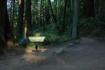
Tucked into the northwest corner of Portland, the Wildwood Trail weaves for more than 30 miles through Forest Park.
Bradley W. Parks / OPB
Part 1 | Part 2 | Part 3 | Part 4 | Part 5
Most Portlanders have hiked at least some of Forest Park’s Wildwood Trail. But in all, it’s 30.2 miles long. That distance makes it America’s longest forested urban trail.
My hiking partner, Gesine Kräztner, and I tackled it in five sections in springtime. We used two vehicles, parking one at the planned terminus of the day’s section, then driving the other to the trailhead.
For leg one, the terminus was the Lower Macleay Park trailhead off of NW Upshur Street.
Part 1: Vietnam Memorial To Lower Macleay Park
Distance: 6 miles | Duration: About 3 hours
The Wildwood Trail starts at the Vietnam Memorial adjacent to the Oregon Zoo and World Forestry Center and circles uphill through Washington Park. You’ll need a map because Wildwood winds through crossing trails that will take you to beautiful spots — and get you completely off track. It happened to us within the first mile, forcing us to double back to the “water tank” feature to get back onto Wildwood proper. In our defense, we were dazzled by the blossoming plums and cherries, but the detour added a good three-quarters of a mile to our hike. (It was worth it.)
This section goes right through the Hoyt Arboretum. The organization (and their famous Tuesday Crew) does a good job of keeping the invasive English ivy under control and maintaining all the trees and shrubs. The region's moderate climate does the rest, allowing for a variety of leafy specimens. It's gorgeous in spring.
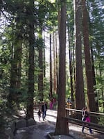
The redwood grove is one of the many highlights of the first leg of the Wildwood Trail.
Jule Gilfillan / OPB
About 2 1/2 miles in, take a quick detour across Fairview Boulevard and down. You’ll find yourself in one of the park’s most scenic spots: the redwood grove. Pause and take it in. Though these coastal redwoods, Sequoia sempervirens, are still just adolescents, they are awe inspiring. Give these majestic stands a few hundred years, and they’ll reach heights upwards of 300 feet. Once you’ve caught your breath, check your map, get back on Wildwood, and head north and west down toward Johnson Creek.
This steep section of trail will take you to W Burnside Street. When you arrive at the Burnside crossing, be careful. Traffic heading up and down the city’s north-south divider is constant and fast-moving.
Once you cross Burnside, the trail makes a steep and scenic ascent to Pittock Mansion, which sits on one of the trail’s highest peaks. On a clear day, the mansion’s lawn has a panoramic view of the Cascades, from Rainier to Jefferson, as well as the Columbia-Willamette confluence. Located at about the 4-mile mark, it also makes a good spot for a lunch stop.
After lunch, head north and downhill through Macleay Park. You’ll see lots of people (and lots of invasive English ivy), but after crossing NW Cornell and heading down into Lower Macleay, you’ll also encounter on the trail’s main stream, Balch Creek. At the Witch’s Castle, which is sadly now covered with graffiti instead of moss, leave Wildwood to take the Lower Macleay Trail and catch back up with your car (if you parked there) at the trailhead.
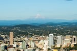
Pittock Mansion is a short walk off the Wildwood Trail's second leg and provides a tremendous view of Portland and Mount Hood.
Bradley W. Parks / OPB
Part 2: Lower Macleay To Firelane 1
Distance: About 6 miles | Duration: 2 1/2 hours
We parked the first car off of NW 53rd Drive a short way off NW Cornell Road down Forest Lane, then headed back to Lower Macleay Park to begin the day’s 6-mile hike.
The Lower Macleay Trail follows the lowest point on the Wildwood Trail, Balch Creek, and is one of the most highly trafficked sections in Forest Park. But once you’ve linked back up with Wildwood, the crowds disappear and it’s just you and the trail runners.
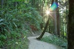
Wildwood's second leg stays cool during the golden hours under the tree canopy, sunlight peeking through where it can.
Bradley W. Parks / OPB
The forest is made up of mostly bigleaf maple and is alive with bird song. In the spring it’s carpeted with trillium and tiny yellow violas locals call “johnny jump ups.” Tucked in with these native perennials is the infamous garlic mustard, a noxious weed with a deceptively cute display of white flowers that almost makes you forget its unwelcome presence. Efforts are being made to control this invasive with herbicide, but small parcels of private land, through which the trail winds, complicates effective treatment. You’ll still see English ivy on many of the trees in this section, but there’s less of it than on the previous leg.
In this section, Wildwood parallels Old Leif Erikson Drive in a lateral traverse across multiple small drains. Each rounding of a significant bend opens views of the verdant slopes, as well as back into the forest. You can hear the faint hum of the city off to the east, but the leafy canopy mostly hides its source.
If the timing is right, consider stopping for lunch just after the ninth milepost, where Wildwood intersects briefly with NW 53rd Drive. About 2 miles beyond, the trail intersects with Firelane 1. Here, take a sharp left uphill and pretty soon you’ll reach the trailhead at one of Wildwood’s highest elevations, about 950 feet. Having started at the trail’s lowest point, you can congratulate yourself for completing a more than 700-foot elevation gain and the journey’s last big ascent.
You’ll also be back at your car. In all, this section of trail takes about 2 1/2 hours, including a stop for lunch.
Part 3: Trillium Trail To Springville Road
Distance: About 8 miles | Duration: About 3 hours
This section starts where we left off last time — at the trailhead off NW 53rd Drive — Forest Lane. After joining the Wildwood off Firelane 1, the route takes you westward over an intermediate crest of the Tualatin Mountains and into a sudden and striking quiet. Occasional songbirds trill above mysterious low-pitched hoots and hums, perhaps from pygmy owls that are known to nest in Forest Park.
Except for some remnant garlic mustard, invasives like English ivy give way to a landscape of natives. In spring, clusters of oyster mushrooms erupt from some of the trees and any ground not covered with maidenhair, bracken or sword ferns is dotted with giant trilliums and brilliant yellow johnny jump up violas. Groves of vine and bigleaf maple fill in between stands of timber. It's an area worth revisiting in October when the turning leaves splash the deep forest green with bright red, orange and yellow.
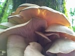
In spring, clusters of oyster mushrooms erupt from some of the trees.
Jule Gilfillan / OPB
This section of Wildwood gets prettier and less populated the farther you head north: It's sheltered from the hum of the city and sparsely traveled, offering an authentic sense of solitude inside our small metropolis.
One note: Wildwood is off-limits to trail biking, though you may encounter a scofflaw or two between the Koenig cutoff trail and Saltzman Road.
It’s also probably seasonal, but each drain in this section has a proper creek flowing through it. You can hear the water as you wind through the forest. Add a little late-afternoon sunlight to illuminate the moss-trimmed tree limbs, and the scene is pure magic.
A short distance past mile marker 18 1/2, a side trail called “Trillium” takes off and slopes upward toward Firelane 7. The steep climb demands more than your legs would like, but you’ll feel rewarded when you reach the Springville parking area and your second vehicle.
Part 4: Springville Road To Germantown
Distance: About 6 miles | Duration: About 2 hours
Starting from the south, this hike begins in a secluded-feeling area and finishes at a popular northern terminus. We saw about 10 people in the first hour of this two-hour hike and then something like 50 trail-goers in the second hour.
The pros of this section include that the trailheads are close together and pretty easy to find. Parking is also relatively easy. Another plus is that the whole 6-mile hike can be done in a couple of hours. It’s a good opportunity to grab a quick hike without much planning. It’s also very user-friendly for families and those who are out for a woodsy stroll. Several shortcuts connect the trails down to Leif Erikson Drive.
The cons include the number of people and dogs you’ll likely meet and the location’s relative noisiness: the trail parallels Highway 30 adjacent to the St. Johns Bridge and is right below the flight path to PDX.
This section of trail has undergone maintenance, so parts of it have been retooled with sturdy flagstones and gravel — a welcome departure from the mud that can sometimes gum up the walking surface. Birdsong fills the woods, which are a good mix of bigleaf maple and Douglas fir with some alder, hemlock and cedar. The understory is filled with sword fern. While there’s not much invasive ivy, there is a lot of “shining (or shiny) geranium,” Geranium lucidum, a pernicious weed with a pretty pink flower.
After you finish, it’s a quick jaunt back to the Springville trailhead to retrieve your second vehicle and then to the Skyline Tavern for — just a suggestion — a post-hike beer.

This sign marks one terminus of the Wildwood Trail at Newberry.
Jule Gilfillan / OPB
Part 5: Germantown To Newberry
Distance: About 5 1/2 miles | Duration: About 2 hours
Drop the first car at the Newberry Trailhead and then head along to Skyline Boulevard back to Germantown to start this final leg.
This part of the trail feels very isolated, but it’s actually quite popular with families with small children as well as older folks leisurely strolling the path.
There’s a great mix of conifers and deciduous trees, with a couple striking cedar groves and an abundant mix of ferns. It’s wonderfully quiet between planes approaching PDX — lots of bird calls and other nature sounds. This section’s hard-packed and level surfaces make it walkable for just about anyone. There are some charred snags in the western portion of the trail, perhaps remnants of the Bonny Slope Fire of 1951.
This section’s also relatively short: You can knock it out before lunch or after the workday during the lingering light of the summer months.
