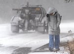
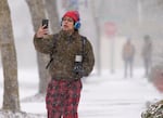
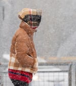
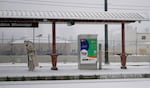
Madison Brosky walks up Southwest Barnes Road in Portland, Ore., Feb. 13, 2025. Brosky’s bus stop was closed so she had to walk to the next stop available.
Kristyna Wentz-Graff / OPB


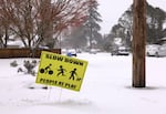

Winter weather alerts are in place for much of Oregon and Southwest Washington Thursday and Friday, including for potential freezing rain and accumulating ice along the Willamette Valley, the Coast Range and the Columbia River Gorge.
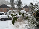
In the southern Willamette Valley, including Eugene, Albany and Salem, snow began falling early Thursday morning. Snow arrived in the Portland-Vancouver metro area not long after. That snow along the valley is expected to turn into freezing rain by the afternoon, forecaster Elizabeth Muessle said in the area forecast discussion Thursday morning.
Weather disrupts traffic, cancels some flights
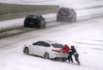
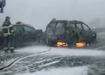
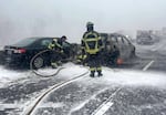
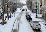
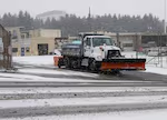
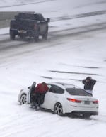
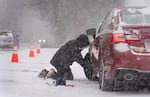
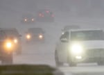
The Oregon Department of Transportation is recommending that people avoid being on out on the roads, as weather conditions continue to create unsafe travel across the state.
Interstate 84 westbound is closed near Multnomah Falls due to a multi-vehicle pileup.
According to Oregon State Police, icy and slick roads paired with limited visibility and near-white-out conditions contributed to the crashes.
About 30 cars were involved in the pileup and four people were transported to local hospitals with minor injuries.
Large amounts of snow has also closed Oregon Route 78 in Harney County, according to ODOT.
“With no signs of improvement in the forecast and conditions expected to worsen throughout the day, we are urging everyone to consider staying home,” ODOT public information officer Mindy McCartt said.
McCartt said it’s unlikely that snow in the Portland metro area will thaw in the afternoon. Significant ice has also formed on I-84 near The Dalles, and on highways through much of the Willamette Valley near Corvallis and Albany.
Check the latest traffic alerts in Portland and throughout Oregon
Anyone who must travel should prepare for rapidly changing conditions. That includes bringing tire chains and supplies needed to wait out the storm in a vehicle, McCartt said.
Meanwhile, snowfall is impacting flights at Portland International Airport. As of 11:30 a.m., the airport had already seen more than two dozen cancellations, spokesperson Allison Ferre said.
“If your flight is canceled, it’s not recommended to come to the airport,” Ferre said. “Just call your airline and manage rescheduling from home. We want everyone to stay safe.”
Airport officials encouraged travelers to check their flights online as well before heading to the airport.
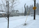
Schools keep kids home, mostly
Dozens of school districts in Oregon and Southwest Washington closed schools for the day Thursday.
As forecasters warned of another round of snow, freezing rain and sleet overnight Thursday into Friday morning, more school districts began announcing closures.
Portland Public Schools, the Beaverton School District and Salem-Keizer Public Schools were among some of the districts that announced Thursday evening there will be no school Friday.
In many cases, district staff also canceled all after school activities. Updates are available here.
Related: See closures and delays from Southwest Washington to Salem
Meanwhile, Medford High School students planned to resume classes Thursday after a catastrophic roof collapse due to snow at the school’s gymnasium forced them to evacuate Tuesday, according to the Rogue Valley Times.
No one was injured in the collapse. Ron Havniear, the Medford School District’s director of safety and security, told the Rogue Valley Times after Tuesday’s collapse that the building is likely a total loss and will need a “full tear down” before being rebuilt.
Thursday will likely just be the start of winter woes in West of the Cascades.
An ice storm warning is in place until 4 a.m. Friday for the central and southern Willamette Valley and the central Oregon Coast Range. In the Portland/Vancouver metro area and the northern Coast Range, a winter storm warning is in effect through 10 a.m. Friday.
“In both scenarios, both snow and freezing rain will create hazardous conditions, just a matter of how much of each,” Muessle said. “Regardless of which scenario pans out, hazardous conditions can be expected that will certainly impact the Thursday morning and evening commutes. With ice accumulations expected, power outages will be possible.”
We'll be posting throughout the day with updates on conditions and forecasts. Here's a quick snapshot of current temperatures and peak wind gusts since midnight. https://t.co/QlTpWyTELE #orwx #wawx #pdxtst pic.twitter.com/ZigH7vMsUH
— NWS Portland (@NWSPortland) February 13, 2025
Hazardous conditions are expected to continue from the Coast Range to the Cascades and in the Gorge through at least midday Friday.
In the northern and central Oregon Cascades and foothills, up to a foot of snow is possible. A winter weather advisory is in place through 10 p.m. Friday.
Most of Oregon east of the Cascades is also under a winter weather advisory for cold weather and moderate to heavy snowfall through 10 p.m. Friday, including Bend, La Grande and Pendleton. High winds are also possible in many areas.