
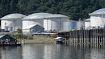
Trucks, barges and tanker ships come to the harbor to pick up loads of gasoline and refined oil products.
Bonnie Stewart / OPB
Sarah Taylor wants to create what she calls “a green working waterfront” on the lower Willamette River. Taylor is the founder of the Braided River Campaign and a longtime environmentalist. She’s on a mission to reimagine the area in Portland’s Linnton neighborhood bordered on one side by the Willamette River and on the other by Northwest St. Helens Road, specifically the industrial area that’s currently home to oil tanks, a rail yard and a Superfund site. Taylor has partnered with local organizations such as Portland Audubon and has been meeting regularly with the city’s Bureau of Planning and Sustainability. Part of her mission includes reckoning with the area’s ugly history. A recent Street Roots article details the history of displacement Taylor showcases on the tours she gives. We’ll dig into some of that history and learn more about Taylor’s vision for the future.
This transcript was created by a computer and edited by a volunteer.
Geoff Norcross: If you drive along Highway 30 in northwest Portland, you’ll see a picture of heavy industry, towering old gas tanks, a rail yard and a stretch of river that is so polluted it’s a superfund site.
One Oregon woman has a vision for this part of the city. She would like to transform it into what she is calling a green working waterfront. Sarah Taylor is the founder of the Braided River Campaign and she joins us now. Welcome to Think Out Loud.
Sarah Taylor: Thank you for having us.
Norcross: You’re actually from this area. Can you tell me about what it was like growing up in the area?
Taylor: Well, I didn’t grow up here. I moved here in 1980. I live on a dirt road like many people in Linnton. We have unimproved roads, most of us don’t have any hook up to the sewer and we love being next to Forest Park. But we also are aware that we live next to a fault line, the Portland Fault Line. We live next to the [Portland Harbor] Super Fund and we live next to the ‘tank farms’.
Norcross: A recent Street Roots article by Brian Oster [lays] out the history of this area [that] starts with a sadly familiar story about white european settlers taking land that rightfully belonged to the Indigenous people there. Can you talk about that?
Taylor: One of the things that the Braided River is trying to do, in addition to having an influence on land planning in the area, is to tell the hidden story of the people who lived here and were displaced over time. If you’re sitting in Linnton, the old riverfront Linnton, there were villages right across the river, next to the Toyota Yard and then at Sauvie Island. What we know is that the river was shallow back then and that it would have been um easy [to go] back and forth between the forest and the wetlands and their villages.
Norcross: You call yourself the Braided River Campaign. A braided river is a shallow river that breaks off into channels and sometimes emerges together again. Was the Willamette a braided river at that time?
Taylor: Yes, there are lots of great old photos and we have those on our website. [braidedrivercampaignpdx.org] We also have a small gallery at the Linnton Community Center where we share these images. There were of course three lakes, Kittredge, Done and Guild’s Lake. As well, we know that Swan Island was actually a true island.
Norcross: What happened to the lakes?
Taylor: The lakes were filled with industrial and Phil sometimes just garbage was put in them. They were at times our city garbage area. And when they dredged the river they put some of the dredge into those lakes.
Norcross: How did the area become the polluted Superfund site that it is today?
Taylor: Well I think most of it came from World War Two. They industrialized the area to make ships with the Kaiser shipyards. And then after [WWII] there was a big scurry to make that area industrial. [So] they tore down many of the housing projects that were built during WWII that were right there in the Guild’s Lake area. And they put a lot of the waste when they took apart the ships. They just put a lot of industrial pollution both on the land and in those lakes and wetlands as well as into the river.
Norcross: And what do you have in mind for this stretch of river now?
Taylor: Well, we like to call it a green working waterfront. We’re aware that down on South Front Street, they’re beginning to build very expensive condominiums where it was once industrial land. And we want to advocate for a system of small industry. We want a transition from fossil fuels and we want [equal] access to the river. We don’t expect an Esplanade or the South Waterfront, but we do want people to be able to fish and have access. We want safe resting places for salmon about every quarter mile. We want people to enjoy looking at ships, looking at boats and to know the industry that’s in their city. We want it to be a place where there’s good training and good jobs for people.
Norcross: Why are the South Waterfront and the Esplanade not a model?
Taylor: Well, I’m not saying they’re not great for that part of the city. But we feel like North Portland and St. John’s and Linnton were always working harbors. We want to maintain that sense of a working harbor because we don’t have that anywhere else. And we don’t want to get rid of jobs. We just want those jobs to work better with the environment and have climate change and equity at the heart of those zoning changes.
Norcross: Is there any place anywhere in the country or maybe even in the world that has made this transition successfully?
Taylor: Well, we sometimes try to think of those places and people throw out ideas. Um, a little like Astoria for people listening, [where] you can walk along the riverfront in Astoria and you can see signs of industry and you can see boats. So, that’s a little bit of a model. But we want Portland to be known for having the best green working waterfront in the whole world. We want [Portland] to be famous for that. If we’re one of the first then that will be great too.
Norcross: I’d like to parse that out a little bit more. Waterfront is self explanatory, but when you say ‘a green working waterfront’, what exactly do you mean?
Taylor: Well it means that we would take care of the river and the creeks that are running out of Forest Park. We would be really aware that the forest is connected to the river. So we wouldn’t put anything that would potentially burn Forest Park next to the park. We would have salmon resting places. We would give businesses incentives for doing green structures versus just building any structure. We would begin to give incentives and excitement to creating those kinds of structures and those kinds of docks.
[For example] you could have a salmon friendly dock and we would begin to give incentives for those types of things. We would honor the greenway. We would have safe bike trails. Right now it’s not very safe to ride your bike on Highway 30. So we would do all those things. Maybe we would have workers housing and some training sites embedded in the green working waterfront.
Norcross: You brought salmon into this and mentioned that there would be resting places in the river along this stretch of the river in northwest Portland. What is a salmon resting place?
Taylor: Well, it’s different than building a whole salmon habitat, which would, of course, go into one of the historic creeks. The river, especially with industry, has gotten too hot. And so a lot of the baby salmon don’t have a place to rest and cool off, especially when we have such hot weather. So it’s a place where there are logs maybe hitched to a dock, where the salmon can rest and cool off as they get older before they go to the sea.
Norcross: What have you heard from the City about this?
Taylor: The city has a process called ‘the comprehensive planning process’. But prior to the comprehensive planning process, they create something called an ‘economic opportunity analysis’ where they’re supposed to analyze economic opportunities in the city of Portland. And a lot of that does focus on this stretch of the river, as that has been called an industrial sanctuary. We tend to call it “a sacrifice zone”.
So they’re in the process of creating that economic opportunity analysis and we’re trying to stay really engaged, um, encouraging them to have focus groups which they agreed to do. So we’re just trying to stay really engaged. I think [the City of Portland has] enjoyed doing business as usual. And we’re saying in light of climate change and equity issues, that we can’t do it the same as usual.
Norcross: Why not? What are the barriers?
Taylor: You have to remember that we call it “a sacrifice zone” because the City of Portland annexed Linnton, Albina, St. John’s and then proceeded to put their dumps there, their sewage there., 90% of all the oil tanks in the state of Oregon and oil trains. They picked one of the poorest neighborhoods in the City and they put all their pollution in that area. So if nothing else, that’s not a way for our city to move forward with its equity goals. We can’t have one area that takes in all the pollution. So that’s one reason why we have to do that. We just can’t have a sacrifice zone.
And then the other reason, of course, is the danger to our whole economy if there was a seismic event and one of the oil tanks was to explode and go into the Willamette or the Columbia. So we actually believe that those things along the river are dangerous for our whole city and our whole region and should be embedded in the economic opportunity analysis.
Norcross: Is the fact that this is a superfund site a barrier to making your vision a reality?
Taylor: No, a lot of us are working on the superfund issues to tell you the truth. We believe that it’s best to be planning for how we want the river to be before they actually start cleaning it up because the cleanup is dependent on the zoning or the future uses. So we think that those two are best going hand in hand.
Norcross: What are some of the other things that are standing in your way?
Taylor: Well, the main thing is that they believe the way that the City does this, maybe State mandated, is that they judge economic opportunity by industrial acreage. And we don’t believe that’s really how you assess economic opportunity. We believe it’s how many jobs there are and what the pathways for creativity and small businesses are? Because there’s lots and lots of acreage with very low employment. So I would say that the formula of acres equals jobs is a barrier.
Norcross: You’re the founder of the Sunnyside Environmental School, but you are not in that line of work anymore. Did you imagine that you would be heading up a massive urban revitalization project like this?
Taylor: No, that wasn’t one of my interests. I’m also a midwife. I do think though that I can see the connection with an environmental school. But I came to see that the contaminants both in the air and in the water and soil impact students and impact children. And so it feels familiar to me because I’m still advocating for mothers and children through this work. As you know, there are many schools that are within a half mile of tanks, of oil trains and of the superfund. And, you know, North Portland has a lot of low income schools, high poverty schools with struggling results. So I hope that this work helps the schools as well.
Norcross: Do you have a timeline in mind?
Taylor: According to the City, um, the economic opportunity analysis will be turned in for city council approval in september
Norcross: And then what?
Taylor: I’m hoping that we will agree before it gets that far. I’m hoping that it won’t be a situation where they present one plan and we present another. So I really want to work with them. Once that’s finished, then they’ll start the North Reach River Plan. They’ve already done the South and Central. They tried to do the North before and it failed. So then we’ll start working on what that actually will look like. That will be an exciting part. And I hope that communities can help with that vision. But what’s tricky is that you can’t do that vision if the economic opportunity analysis says we have to have more industrial land. So that’s why we have to weigh in at this time.
Norcross: Sarah Taylor thanks so much, and good luck.
Contact “Think Out Loud®”
If you’d like to comment on any of the topics in this show or suggest a topic of your own, please get in touch with us on Facebook or Twitter, send an email to thinkoutloud@opb.org, or you can leave a voicemail for us at 503-293-1983. The call-in phone number during the noon hour is 888-665-5865.