
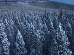
Snow Spotter is a citizen science project launched through University of Washington in which volunteers classify time lapse images from forest canopies at four sites, including Niwot Ridge in Colorado, shown in this image.
University of Washington
Snow Spotter is a citizen science project where volunteers around the world scan time lapse images of forested canopies in Washington, Alaska, Colorado and Europe for the presence of snow on tree tops. Since its launch in 2017, the project has grown to include other sites around the world and has been helping University of Washington researchers refine models for predicting how much annual water a region gets from melting snowpack. The data also reveals the role densely packed forests play in snow capture and release, and how forestry management practices in response to climate change may impact the amount of snowmelt that ends up recharging reservoirs and aquifers. Joining us now is Cassie Lumbrazo, a doctoral student at the University of Washington’s Department of Civil and Environmental Engineering, who recently published a paper using data from Snow Spotter in the journal Water Resources Research.
Note: The following transcript was created by a computer and edited by a volunteer.
Geoff Norcross: This is Think Out Loud on OPB. I’m Geoff Norcross, in for Dave Miller. There [is] about 40″ of snow on Mount Hood right now. That’s easy to measure, because snow falls directly on the mountaintop, nothing gets in the way. Snowpack is a lot harder to measure where there are lots of trees. Now there’s a project that will better measure how much of our snowpack falls in the forest. It’s a citizen science initiative called snow spotter. And here to talk more about the project is Cassie Lumbrazo. She’s pursuing a doctoral degree in Civil and Environmental Engineering from the University of Washington. Cassie, welcome to TOL.
Cassie Lumbrazo: Thank you so much for having me.
Norcross: So before we get into the details of Snow Spotter, it might be good to be reminded why it’s important to get good measurements of our snowpack in all the places that it exists. Why is that important?
Lumbrazo: In the Pacific Northwest, the snowpack is incredibly important for our drinking water. So the snowpack provides a natural water storage in the mountains for us. It’s better than any water storage a human has been able to create. The snow falls way up in the mountains and gets stored there all winter, and in the springtime, it melts out, and we end up with continuous running water in our streams all summer, even when it’s not raining. And that snowpack is really important for water later in the year, when we end up with those droughts and less precipitation.
Norcross: So what is the problem with snow, when it falls in the trees, when it comes to measuring our snowpack?
Lumbrazo: It becomes more complex. So there’s one factor of knowing if it’s snowing or not, which already sometimes can be difficult and challenging. And then another factor once you incorporate forest, is knowing whether or not the snow has fallen into the canopy, or landed on the ground. And although it can be really easy with our eyes to see this process, it can be complex to model, and there’s a lot of variability across a landscape on how much that’s happening and where it’s happening. So in order to get the snow on the ground correct in forested areas, we need to know when there’s snow in the trees as well.
Norcross: Okay, so now we have this Snow Spotter project, how does it work?
Lumbrazo: Snow Spotter is a project posted on a citizen science platform, and essentially you can just sign up, create an account on the platform and start contributing to Snow Spotter. It’s a site where we upload time lapse images. So we have cameras in the mountains taking photos every hour of snow, in the canopy or not. And we upload these images to our Snow Spotter website, and citizen scientists tell us whether or not there’s snow in the canopy at a certain time step or not. And they can tell us if there’s snow in the canopy, or if there’s not snow in the canopy, or how much there is. Essentially, we can use this data later on to help inform our models, if there’s snow in the canopy or not, at certain times.
Norcross: In fact, I clicked on an image on Mount Steel in Washington that was taken last November. Didn’t see any snow on the trees, although I saw snow on the ground. So that’s a ‘no’?
Lumbrazo: Yep, exactly.
Norcross: Okay. How many volunteers do you have working on this?
Lumbrazo: I think when it first started, we initially got a ton of volunteers, about 4,000 or 5000. And now we’re up to almost 9000 volunteers that are participating in contributing to the project.
Norcross: Why is it good to have a lot of volunteers looking at the same images and making, one would assume, the same judgments about them. How is that better data?
Lumbrazo: It’s really important to have multiple people looking at one image. So of course, even if we’re asking a simple question like ‘yes or no, is there snow in the canopy?’, people can have different ideas on what is a full-blown interception event of snow being in the canopy, and sometimes there’s little pockets of snow here and not there. So for even a simple question, it’s really good to get a lot of people to answer, so that we can get really accurate data. We can actually just take an average of all the responses and then we can use that data point as our final answer. and then when we start asking more complex questions, of course it’s important to also get a lot of responses. We start if we ask people about their snow on the sensors or other other objects in the image. It’s interesting, because it’s really easy for our eyes to see this type of thing. And humans are really good at detecting if there’s snow in the trees or not. But when you try to do something in machine learning like this, it’s pretty hard for a machine learning algorithm to know if there’s snow, and if it’s snow on the trees, or if it’s clouds or snow on the ground. So like you said, you saw an image where there’s snow on the trees, where there wasn’t snow on the trees and there was snow on the ground and that’s easy for our eyes to see. But sometimes finding other methods to classify that can be pretty difficult.
Norcross: But even with people, they can perceive things differently. What do you do with responses that are disagreeing with each other? You know what I mean?
Lumbrazo: Yeah. There are times where people certainly disagree. So in those situations, we will go look at that specific event, and see what’s going on. Maybe it was a partial intersection event where there was some snow, and some of the trees or not. And so we’ll actually just go investigate those events ourselves, but for the most part we have a large degree and the volunteers. So people tend to agree on this simple question, that there’s snow on the trees are not, at a 95% rate. So it’s very few events where we have a disagreement, people disagreeing. And in those cases it’s actually a pretty interesting event. So it highlights the full event that we can go investigate.
Norcross: If you’re just tuning in, we’re talking about a citizen science project to measure snow that falls on trees and how it contributes to snowpack in many parts of the world. Cassie Lumbrazo is part of the project at the University of Washington. Cassie, how did you decide where you would take your pictures and where you would get your measurements?
Lumbrazo: The project actually started in Washington State in the Olympic National Park. The cameras went up to cover a large spatial range in the Olympics. Because there’s no roads, there’s not a lot of observations in the Olympics, specifically of precipitation, of snowfall, and snow in the canopy. So the project started there. The goal was to cover a large spatial distribution across Olympic National Park. And that project was hugely successful. And we noticed that there was a large spatial variability in whether or not there’s snow in the canopy, just in the Olympics. And so that’s really where the project started. And since then we’ve taken images from a lot of other places, not just our images: images that other people have taken for other purposes, and used for our purpose. So originally, though it was to cover spatial variability in Washington State, to see how variable across just [in] the Olympics this pattern is.
Norcross: What have you learned so far from the project about how forest snow contributes to our water supply, as opposed to mountain snow?
Lumbrazo: So a few things that this work has highlighted is that there’s large differences in how the forest intercepts snow, depending on where you are just in the western part of the US. So in Washington, for example, it’s really obvious that [if] you’re skiing in Washington, you feel how heavy our snow is. A lot of people call it ‘cement’ or Sierra cement. And what happens is that snow actually gets really stuck in the trees and can stay there for 30 days at a time and never leave. And so snow that actually stays there and doesn’t make it to the snowpack below for those 30 days. As opposed to data we compared, from a Snow Spotter to a site in Colorado, where if you go skiing there, you feel how light the snow is. People love skiing because it feels like powder, but what happens is it actually gets intercepted in the canopy and then it blows out very quickly. And in those cases we can lose that snow, we can actually end up losing that snow back to the atmosphere so it can go directly to water vapor and it never sees the snowpack. So what we learned in this project is really that there’s different climate variability in how snow is being intercepted in the canopy, and that ends up impacting how much snow ends up on the ground.
Norcross: More broadly, how is climate change making it harder for people like you to study the availability of water here in the Pacific Northwest?
Lumbrazo: Climate change certainly throws a wrench into everything we’re looking at, of course. One way that this is more challenging, is that there’s a lot of unpredictability in our events, and a lot more rain-on-snow events. So we’ll have temperatures increase throughout the winter season, and we end up getting precipitation falling as rain, instead of snow. So you’ll have a snowpack on the ground, and then get a full rainstorm on top of it. So it creates challenges in how variable and how complex our meteorological events become, and that becomes more complex to try and model and simulate later on.
Norcross: Okay, so how does someone sign up for Snow Spotter if they want to participate?
Lumbrazo: People can, if you have a cell phone, download an app called “Zooniverse,” the platform it’s posted on, and then you can search in the ‘climate’ section for projects, and you’ll find us. Or you can just search Snow Spotter. You can sign up, I think you just make an account with the username and password, and then when you click on Snow Spotter, you can see our site, you can scroll around and look at some of the previous research from the results, or you can just get started. You can click on one of the workflows, whatever site you want. You can click on a site in Washington or Colorado or in Switzerland, and you can start classifying images for us. What will happen is that something will pop up and say, ‘please look at the tutorial so that you can see what type of questions we’re asking and what type of data we’re looking for’. And then you can jump right into getting some live images and processing data for us.
Norcross: Okay, you’re in Oslo, Norway right now, but you’re going to be coming back to the Pacific Northwest this fall. What will you be working on then?
Lumbrazo: I’ll be back in the Pacific Northwest in September and October, and we have some exciting work happening in the eastern Cascades in Washington. There’s going to be a project working with the Nature Conservancy and the Washington State Department of Natural Resources. We are looking at how different forest thinning techniques and forest management techniques will impact our snowpack on the ground. We’re going to set up a study site, and set up quite a few time lapse cameras in [the] eastern Cascades, and these time lapse cameras will cover a range of different forestry management practices, so some thinning, some clear cutting. And we’re going to see how we’re going to use these images and upload the Snow Spotter, so we can see how the interception patterns might change, or how the snow on the ground might change in these different forest management practices.
Norcross: Many more images to look at. Cassie Lumbrazo, it was a pleasure to talk to you. Thank you so much.
Lumbrazo: Thank you for having me.
Norcross: Cassie Lumbrazo is a doctoral degree candidate in Civil and Environmental Engineering at the University of Washington.
Contact “Think Out Loud®”
If you’d like to comment on any of the topics in this show, or suggest a topic of your own, please get in touch with us on Facebook or Twitter, send an email to thinkoutloud@opb.org, or you can leave a voicemail for us at 503-293-1983. The call-in phone number during the noon hour is 888-665-5865.