Snow might not fall all the way to the Willamette Valley floor after all. That’s according to the latest weather forecast by the National Weather Service.
Forecasters on Wednesday said a storm that could have brought at least an inch of snow to the valley had shifted toward the north Oregon Coast and Southwest Washington.
❄️2/18 UPDATE: The surface low is now forecast to move towards the north Oregon coast, favoring little to no snow accumulation below 500 feet in the Willamette Valley, Portland metro & at the coast. This is due to south winds maintaining above freezing temperatures. However... pic.twitter.com/xvNbfjXOg0
— NWS Portland (@NWSPortland) February 18, 2026
The new forecast “favors little to no snow accumulation below 500 feet in the Willamette Valley, Portland metro and at the coast.”
Southerly winds flowing across the Interstate 5 corridor and above-freezing temperatures will likely squash any chance for accumulating snow, according to the NWS area forecast discussion.
But there is still about a 20-40% chance some areas below 500 feet could still see a dusting to 1 inch of wet snow by Thursday morning, forecasters said.
Those areas include Ridgefield and Longview in Washington as well as folks in St. Helens, Scappoose, and more.
The weather service issued a new winter weather advisory Wednesday for additional snow accumulations that includes the Cascades foothills, the Coast Range and some areas of Portland’s West Hills.
That advisory will expire at noon Thursday.
See the latest NWS weather alerts
Tyler Kranz, a lead meteorologist with the weather service, said on Tuesday it’s unclear where the snow will fall — if it falls at all.
“It looks like it could form anywhere between Eugene and Portland, so really the entire Willamette Valley is fair game,” Kranz said.
The band of snow possibly falling this week in the valley seems to be on the narrow side, meaning it’ll only be around 50 miles wide, he said.
According to Kranz, temperatures will warm up into the low to mid-40s on Thursday afternoon, which will slowly melt any snow that does fall on Wednesday night.
Eastern Oregon
A winter weather advisory remains in effect until Thursday evening for portions of the Oregon and south Washington Cascades.
Many areas above 1,000 feet could see snow accumulations of 4 to 10 inches through Wednesday night.
Another 2 to 4 inches of snow could fall in those areas on Thursday, according to the National Weather Service.
Traffic updates from TripCheck
A winter weather advisory is also in effect through Wednesday afternoon for the Grande Ronde Valley, Wallowa County, the southern Blue Mountains of Oregon and the Ochoco-John Day Highlands.
NWS warns up to 3 inches of snow on the roadways could cause dangerous driving conditions.
Oregon Coast
Oregon’s Central Coast Range Mountains will also see snowfall through Thursday night.
Kranz said with all that snow, roads will be hazardous.
“If someone plans on driving over the Coast Range to or from the coast, or if they plan on driving over the Cascade Passes, they’re definitely gonna need to be prepared for slippery snow-covered roads and hazardous travel conditions,” he said.
Kranz suggests carrying a driving kit in your vehicle if you do have to hit the road this week. He recommends filling it with bottled water, blankets, and nonperishable food items.
Southern Oregon
Snow showers continue tonight into Thurs with impacts to the morning commutes. Plan for extra commute time and slippery roads through the morning. Snow showers linger on the eastside Thurs evening. Strong low enters the region this weekend - moderate to potential major impacts. pic.twitter.com/YU1DvCupe0
— NWS Medford (@NWSMedford) February 18, 2026
People in Southern Oregon are also bracing for snow this week. The weather service issued a winter storm warning on Tuesday for areas above 2,000 feet.
Forecasters said heavy snow is expected with total accumulations reaching 2 to 6 inches. That storm warning is expected to last until 10 a.m. Thursday.
A winter weather advisory also remains in place for Jackson County until Thursday morning. Forecasters said areas below 2,000 feet across the county could see up to 3 inches of additional snow.
Not enough snow on Mount Hood
It’s been a tough winter for the owners of the Huckleberry Inn at Government Camp.
“I haven’t seen one of these as long as I’ve been here,” said Ed Rogers, who owns the family-owned business that’s been operating in the heart of Government Camp since 1966.
Rogers has been praying for snow.
This week, those prayers may be answered.
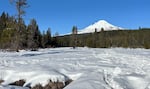
A few inches of snow melt under the winter sun on the Trillium Lake loop trail near Mount Hood, near Government Camp, Ore., on Jan. 24, 2026.
April Ehrlich / OPB
The snow should blanket most of the mountains by mid-week.
But even with the snow falling in the mountains, the winter has been so dry that it likely won’t be enough snow to make up for what the state has missed in the earlier winter months.
“This will help out by adding possibly a foot to two feet in snow when it’s all said and done to the Cascades,” David Bishop, a meteorologist with the National Weather Service, said. “It will help out with some of the deficit, but it’s not going to wipe it out.”
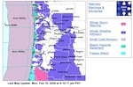
This forecast map provided by the National Weather Service shows a winter weather outlook for the I-5 corridor as of late afternoon Monday, Feb. 16, 2026.
Courtesy National Weather Service
Bishop said although the weather service is feeling fairly confident there will be several inches of accumulation on the valley floor this week, it remains unclear where exactly it will fall.
Bottom line, the meteorologist said: keep an eye on the weather report if you have travel plans, as it’s changing quickly.
For Rogers at Government Camp, he won’t stop praying for snow.
“We need at least 10 feet of snow,” he said.