
Multnomah County Transportation Division crews work to clear mud and downed trees from Southeast Hurlburt Road, just east of its intersection with Southeast Evans Road, after a landslide in Corbett, Ore., on March 13, 2026.
Eli Imadali / OPB
An atmospheric river that dumped several inches of rain throughout northwest Oregon and Southwest Washington exited the region Saturday morning. But flooding and landslides continued to cause issues throughout the day.
In Columbia County, Rivers Edge RV Park in Clatskanie flooded Saturday morning, displacing about 200 people.
The Columbia County Emergency Operations Center was activated for multi-agency coordination.
“Our priority is making sure residents are safe and have a place to go,” said Corey Padrón, the director of Columbia County Emergency Management. “We encourage residents to stay alert, avoid flooded areas, and follow guidance from local officials.”
Most of the flood watches and warnings in the area expired by about 3 p.m. Saturday.
But in Cowlitz County a flood warning was still in place for the Cowlitz River near Kelso through Sunday morning. And in Eastern Oregon’s Umatilla County, a flood warning remained in place for parts of the Umatilla River through Sunday morning.
The National Weather Service noted Saturday that while the flooding impacts would continue, no additional rainfall was expected.
Landslides cause traffic issues
The heavy rain over the last few days led to hazardous conditions across the region, including on Saturday a debris slide that temporarily closed all lanes of Interstate 5 northbound at Woodland, Washington.
The closure caused backups for miles, and for hours, in the area. But lanes started to open up and traffic started moving again by early Saturday afternoon.
UPDATE: Left two lanes of NB I-5 in Cowlitz County are now open!
— WSDOT Southwest (@wsdot_southwest) March 14, 2026
The right lane remains closed while crews finish clearing debris from the slide. There's about 4 miles of backups, so expect delays as traffic starts moving again.
Thanks for your patience, and drive safely! https://t.co/1HcZgMyJhH pic.twitter.com/7hn1Rlf6OS
See the latest traffic updates at TripCheck.com
Amtrak reported on Saturday that all passenger train service between Portland and Seattle was halted due to a landslide south of Centralia.
The slide brought down trees and mud onto the tracks, so BNSF implemented moratorium for passenger rail trains until at least Monday.
Trains continued to run on regular schedules north of Seattle and south of Portland.
Get the latest status updates on Amtrak Cascades service
Record rainfall
Some areas of northwest Oregon saw record rainfall during the past few days, according to the National Weather Service.
The Portland International Airport broke a single-day rainfall record on March 12, with 1.73 inches of rain.
Astoria saw two record-breaking days on March 11 and 13. Friday saw the 1.81 inches of rain hit the city, shattering a record set back in 1920.
☔️Another round of rain is on the way! The Atmospheric River which has been providing all our rainfall the last few days will shift southward again this afternoon and tonight. Remember, if you ever happen to encounter a flooded roadway turn around, don't drown. #wawx #orwx pic.twitter.com/0HIfcHcIU3
— NWS Portland (@NWSPortland) March 13, 2026
“The ground was definitely very saturated and susceptible to all those impacts, whether it be small stream flooding, river flooding, landslides,” said Noah Alviz, a meteorologist at the National Weather Service in Portland.
But residents can expect at least some relief from the precipitation. The rain is expected to subside through Monday, Alviz said.
Other landslides and mudslides
On Thursday, a landslide closed all lanes of the Historic Columbia River Highway east of Corbett. The roadway was still closed Saturday, with no estimated time for reopening.
Also on Thursday, a mudslide on Northwest Cornell Road in Portland near the Bird Alliance of Oregon also shut down traffic in both directions.
And another landslide was reported Thursday around noon outside of an apartment complex in Portland’s Markham neighborhood.
Portland Fire said no one was injured and the city’s geotechnical engineering specialists will continue to evaluate the site.
High water rescues
In Washington County, emergency crews responded to a report of a couple stranded inside their car in high water along Rock Creek. The car stopped working as the couple tried to drive through deep water on the roadway, according to the Washington County Sheriff’s Office.
The two were unable to swim and were rescued by marine deputies. They were uninjured.
Early Friday morning, crews in Forest Grove rescued a driver and his dog that were stuck in high water on Southwest Fern Hill Road.
Forest Grove Fire used the episode as a reminder for people to never drive through flood waters.
Driver & dog rescued from car stuck in flood waters on SW Fern Hill RD this morning at 3:25am. Never drive through flood waters. Remember to turn around, don’t drown. pic.twitter.com/StrfDYeZMP
— Forest Grove Fire (@ForestGroveFire) March 13, 2026
Clackamas County flooding
While a flood warning was in place along Johnson Creek, earlier in the week, disaster management officials in Clackamas County were keeping a close eye on the weather and river gauges.
Spokesperson Scott Anderson said county staff was monitoring the impacts of the heavy rain along with the Clackamas County Sheriff’s Office, the Oregon Department of Transportation and others. But the county’s emergency operations center was not activated.
Heavy flooding and landslides in mid-December led to Level 3 evacuations and caused widespread damage along the Clackamas and Sandy rivers. But Anderson said this weather system was not extreme as that one was.
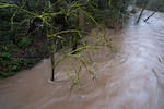
Waters rise in Johnson Creek in Portland, Ore., on March 12, 2026.
Eli Imadali / OPB
He said those floods did have significant and lasting impacts, including log jams and other shifts in river movement. Some lower areas that don’t always see flood impacts could still notice a difference.
“It’s almost impossible to know every single thing that changed as a result of the December floods,” he said. “If community members are experiencing a life-threatening flood, they should evacuate and/or call 911 for assistance. If it isn’t life-threatening, they can call the non-emergency number, which is 503-655-8211.”
And the county urged people to sign up for Public Alerts, check their go-kits, to keep up with traffic alerts and to know where the closest sandbag stations are.
Portland’s Big Pipe
The increased rainfall also caused Portland’s Big Pipe system to reach capacity Thursday morning.
City officials issued a combined sewer overflow advisory for the Willamette River due to increased bacteria levels.
They urge residents to avoid contact with the river during the overflow. The impacted area includes a stretch of the Willamette River downstream of the Ross Island Bridge.
By Saturday morning, the Big Pipe was down to 78% capacity. But the CSO advisory was still in place.
Ways to stay safe
Officials said there are a few ways people can stay safe, even as the storm continues.
Portland Bureau of Transportation spokesperson Dylan Rivera told reporters in a Friday press conference that roads impacted by landslides will be barricaded and urged the public to stay away.
“When you encounter the actual site of a slide that we’ve marked with barricades, do not cross those barricades,” Rivera said. “You’re putting your own life at risk, and potentially others.”
Residents are also encouraged to clear out their gutters to allow water to drain more quickly.
Downed trees also remain a concern. Portland Parks and Recreation spokesperson Mark Ross said his department has responded to about 60 tree emergencies since the atmospheric river began. Those include trees blocking roadways and hanging limbs that pose a danger to the public.
“If you see a tree down, please don’t try to move it yourself. We have experts to do that,” Ross said. “We have been fortunate to get through this event so far with no staff injuries.”