
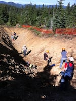
Scientists begin cleaning debris from a 15-foot deep trench on Blue Ridge near Mount Hood. They hope exposed geologic layers will reveal clues about the how big and how often earthquakes happen on a fault line found here.
Vince Patton
OPB's Oregon Field Guide Producer Vince Patton joined scientists this week as they got their first up close look at what could be the signature of an earthquake fault line.
Here is a transcript of his in-studio conversation with OPB Radio's host, Beth Hyams:
BH: If a fault line hides in the forest for so many centuries, how do the scientists find it?
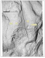
VP: It's all because they started just five years ago doing sophisticated laser mapping called LIDAR. That is what opened their eyes. They're the most sophisticated maps ever made. They're revealing traits across the ground because the laser, or I should say, the computer after they digest all the data, can strip away all the vegetation, all the trees, so they see the real terrain itself and Ian Madin, the chief scientist at the Oregon Department of Geology and Mining Industries, said low and behold, they found the clear signature of an earthquake faultline.
Ian Madin (recorded: We were able to see this fault running across the landscape, as clear as day. It looked like somebody had taken a Sharpie and drawn a line on the map. And that allowed us to locate a place where we could come in and dig a trench.
BH: This sounds like just exactly the kind of puzzle that geologists love to dig into. What kind of things are they doing there this week?
VP: They're in with their excavator digging a big trench, two of them, 15 feet deep. And then we watched them pull out shovels and brooms and even a leaf blower to blow away the debris so they can really look at the layers of the earth. They're looking for uplift where rocks would be at a severe angle -- signatures of an old earthquake. And of course the holy grail, what they'd love to find is some old plant material, some old carbon so they can do carbon dating. They know that's not very likely.
BH: I bet the real question that they really want to nail down is, how active the fault might be.
VP: Exactly. That's what they want to learn and if the earth shoved the ridgeline up six to eight feet, well, there's a good bet, they say, that could have been a 6- or 7-magnitude earthquake. Now they do know that this split apart a glacial debris flow and that originated in the last ice age, so that gives them a rough age: 10 to 12,000 years ago that quake had to have happened to split that glacial moraine apart. And in geologic time 10 to 12,000 years is considered active.
BH: What it means is that Mt. Hood is not only an active volcano, but it's also got an active earthquake zone running right next to it.
VP: It may be even more intriguing than that. Ian Madin says the fault line might not just stop at Blue Ridge, where they see it on the map.
Ian Madin (recorded): It may very well be that this fault system goes clean under the mountain and comes out the other side. We have found some scarps on the Government Camp side of the mountain. They're not as clear as the ones we have on this side but there is some evidence that it passes through the mountain and keeps on going.
VP: But their laser map stops short. They don't cover the land south of Government Camp. So the mystery will have to wait for a little more money to continue that high-tech mapping and until then, they're digging in the dirt. They've got teams from Oregon State University, from the U.S. Geological Survey, and the Department of Geology all out there for two or three more weeks. Then they'll fill in the trench and that fault line will disappear again.
BH: Well, we will just have to wait and find out what they learn. Thanks very much, Vince.