The National Weather Service issued a red flag warning for much of Central and Eastern Oregon on Saturday, as hot and windy conditions pose an extreme wildfire risk for a region already hit hard by multiple large fires.
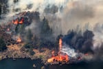
The Bench fire burns along the banks of the Deschutes River on Saturday, July 25, 2026, in Jefferson County, Ore.
Noah Berger / AP
5:30 p.m: Round Butte Fire moving rapidly outside Madras
A fast-moving, wind-driven vegetation fire named the Round Butte Fire spurred new evacuation orders for parts of Jefferson County Saturday.
According to the Jefferson County Sheriff’s Office, the area west of Metolius, Oregon, to the Deschutes River is under Level 3 “Go Now!” evacuation orders. The city of Metolius itself is under a precautionary Level 2 “Be Set” order.
The Round Butte Fire is burning across the Deschutes River from the Bench Fire, which has burned more than 67,000 acres, threatening multiple areas including the Warm Springs Reservation near Madras. The Bench Fire was 46% contained as of Saturday morning.
The sheriff’s office urges residents near the Round Butte Fire to sign up for alerts at oralert.gov.
12:00 p.m: Grasshopper Fire officials bracing for Saturday weather
The Grasshopper Fire, located just east of Mount Hood, remains at 0% containment as of Saturday morning and has burned more than 23,000 acres.
At a community meeting at South Wasco County High School in Maupin on Friday, fire officials said they’ve started to make progress, but that surviving the dry and powerful winds this weekend would be vital. Wasco County Sheriff Lane Magill said they expect the wind to be at its strongest around 4 p.m. Saturday, and that just one ember could start a large fire.
“Tomorrow is going to be a key day for us based on the weather,” Magill said on Friday. “We have got to get through this weather event.”
The Federal Emergency Management Agency on Monday authorized funds to help fight the Grasshopper Fire. More than 400 personnel are currently on the ground. There are more than 18,000 firefighters working on wildfires across Oregon, according to Seth Mitchell of California Incident Management Team 6, who’s assisting with the response.
10:00 a.m: National Weather Service says Saturday’s fire weather is particularly dangerous
Matt Callihan, lead meteorologist for the National Weather Service in Pendleton, said a cold front coming into the area will bring very warm and windy conditions. That, coupled with the extreme drought in most of the region, could easily cause any fire to rapidly spread.
“The reason we’re seeing these conditions… is that things are really dry,” Callihan said. “We haven’t seen rain in a long time. It’s been hot, so that’s allowed fuels to cure pretty well.”
About 1.8 million acres have already burned in Oregon this wildfire season, according to the Oregon Department of Forestry. The Columbia River Gorge and the east side of the Cascades are in particular danger during this red flag warning, Callihan said.
More than 25,000 Oregonians are under some kind of evacuation orders. Some of the largest evacuation areas are in Crook and Wheeler counties in Central Oregon, and in the southeastern part of the state in Harney and Malheur counties.
Going into the weekend, however, some evacuation levels have decreased. The Deschutes County Sheriff’s Office has reduced evacuation levels for the Akawa Butte Fire near Sisters, and the Red Cross shelter at Sisters High School has closed.
Last week, it was the No. 1 priority wildfire in the nation, but a team of more than 1,200 firefighters have increased containment to 62% as of Saturday.