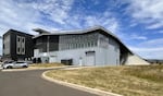
Pictured in this provided photo is Oregon State University’s Gladys Valley Marine Studies Building in Newport. This is the only integrated tsunami vertical evacuation structure in the state.
Courtesy of Oregon Department of Emergency Management / OPB
In the event of a tsunami triggered by a Cascadia Subduction Zone earthquake, residents of coastal communities in Oregon have less than 20 minutes from the time ground shaking starts to safely evacuate Tsunami Hazard Zones. That’s according to a new report published last week by the Oregon Department of Emergency Management.
According to the report, for many residents and visitors in the area, that wouldn’t be enough time to reach high ground.
The report releases guidance for implementing Vertical Evacuation Structures on the Oregon Coast — buildings that are made to withstand tsunami waves.
Officials say the state only has one such structure, and needs at least 15 to adequately provide for a disaster of that scale.
Bridget Good is the mitigation program analyst at the Oregon Department of Emergency Management, and she joins us to discuss the report and the subsequent recommendations.
Note: The following transcript was transcribed digitally and validated for accuracy, readability and formatting by an OPB volunteer.
Geoff Norcross: From the Gert Boyle Studio at OPB, this is Think Out Loud. I’m Geoff Norcross. In the event of a Cascadia Subduction Zone earthquake off the Oregon coast and the resulting tsunami, many coastal residents will have less than 20 minutes to get to higher ground. That won’t be enough time for a lot of them. A new report from the State Department of Emergency Management has guidance for building what are called vertical evacuation structures that can withstand the tsunami. The report says we have one and we need dozens more. Bridget Good is a mitigation program analyst with the agency, and she joins us now. Bridget, welcome to the show.
Bridget Good: Yeah, thank you for having me.
Norcross: Can you describe this one structure that we have? Where is it and what does it look like?
Good: Yeah, absolutely. So we have one structure, it’s part of the Hatfield Marine Science Center down in Newport. It’s called the Gladys Valley Marine Studies Building. It is a multi-use functional facility that incorporated vertical evacuation structure components into the design with basically a rooftop refuge. It can support 920 people roughly for 48 hours with the disaster cache of supplies that they have at the top of that roof.
Norcross: So it’s a structure that was put on top of the structure. It’s kind of a little extra something on top of the Hatfield Science Center?
Good: Yes, specifically in this one building. And so a lot of these vertical evacuation structures provide sort of a rooftop refuge that is built above the tsunami inundation level of flooding that we could see in that location based on current modeling.
Norcross: OK, that’s one, we need more. Can you give me a sense of where else you think these structures could be that would be helpful?
Good: Yeah, that’s a great question. And it’s a complex question. We know that with a Cascadia Subduction Zone major earthquake, we could see probably a shaking of 3 to 5 minutes. And the tsunami waves could come into certain areas along the coast within as little as 10 minutes after that shaking stops, and other areas might get more like 20 minutes, as you were saying. And so, DOGAMI has done some really amazing evacuation modeling for pedestrian traffic, and they can look at how long it would take to get from one point to natural high ground.
And there are locations along the coastline where natural high ground is just unfortunately too far to reach in the amount of time that people will have before that first wave comes. Seaside is a good example of a city where they are going to have certain areas along their coastline that are too hard to reach natural high ground and would benefit from a vertical evacuation structure. But along the coast, we have not done a formal study here in Oregon like Washington has done. Washington probably needs between 58 and 82 vertical evacuation structures. Rough estimates for Oregon is that we probably need close to 15 to 20 more.
Norcross: Hmm, and you mentioned Seaside as a possible example. If you were able to build one of these evacuation structures, where would it go? Would it live on top of an existing building like at the Hatfield Science Center?
Good: That’s a great question. So, vertical evacuation structures can really take form in a lot of different ways. They could be a multi-story parking garage, community, commercial, or residential facilities, they can be schools. They can also be towers or engineered berms. And this guide doesn’t actually specify where they should go. It’s more of a roadmap for communities to start having those discussions, and they would really need to pull into their project management team, tsunami modelers who can look at where these might be best. They want to pull in evacuation modelers to say, OK, where are our most at-risk vulnerable populations, and where can we build the structures, and then what type of structure does our specific community benefit from most? So it really does take a lot of planning to figure that out for each community.
Norcross: You mentioned that Washington has already done this work. I’m wondering what lessons you’re learning from their experience when applying it here?
Good: Yeah, that’s a great question. So, they actually came up with their manual for vertical evacuation structure first, and have done a lot of amazing work. They have a safe haven project, which actually the state worked with different communities, and they looked at where those tsunami vertical evacuation structures could best be placed strategically along the coastline. So, I’d love to see work move that direction for Oregon, but we definitely wanted to get a resource like this out.
We worked with DOGAMI extensively on this, so we had funding from FEMA and from NOAA to help us put this guide together as a way to start those conversations. Washington has two vertical evacuation structures as well, and so those case studies for those two buildings and the one for Hatfield are included in the guidance document to kind of talk about what has worked and some things that could be improved upon for future buildings.
Norcross: Ideally, Bridget, what is the maximum distance you would want anybody, within the inundation zone on the coast to have to travel to make it to one of these structures? How easy could it be?
Good: Yeah, that, well, that would depend on the location. The reality is that we want that vertical evacuation structure to be located in such a distance that people can reach it in between the time that that shaking stops and that first wave hits, and that time frame is so drastically different along the coastline. The first wave arrival times are different per community, and so there’s research within the manual that talks about what those time frames might look like. And then DOGAMI’s beat the wave maps are those evacuation models that show you how long it takes to get from one point to another. And so it really, we just need to find that sweet spot of, how can we reach high ground before that wave comes, given a specific location.
Norcross: What needs to happen for these structures to be built? I know it’s a complicated problem that brings in funding. It brings in zoning. It brings in lots of things, but generally, what are the hurdles?
Good: Yeah, funding tends to be a big one, right? These are not cheap structures to build. When we look at the tower, for example, that was built up in Washington, the Tokeland tower, the cost for that was roughly 4.2 million, and 3 of that came from federal grants. And then the 1.2 million leftover was covered by that tribe, by the Shoalwater Bay Indian Tribe. And so, there’s a lot of planning that goes into just thinking about, how do we fund these? They typically, if it’s going into a multi-use building, it can cost roughly 20% more to incorporate these vertical evacuation structures into a building that’s going to be a school or a commercial facility.
The very first vertical evacuation structure in the country was Acosta Elementary School up in Washington. And they were able to keep the cost to only 10% above construction with some really solid planning. And they’re exploring things like taxes, utility fees, bonds, federal grants, and really pulling in amazing teams that can start that planning early on, cause addressing the funding tends to be that first obstacle.
Norcross: I’m wondering what it says to you that we’re even having this conversation and that we’re accepting the fact that some people can’t get to higher ground, they just need to get to a higher place, and we’re talking about siting and we’re talking about funding. I’m wondering what this says to you as it reflects our understanding of the big one and the tsunami and the danger that we’re in on the coast?
Good: Yeah, personally, I am so grateful for this conversation and for the opportunity for this document to be made public because this is such a critical issue that needs to be discussed. We have some new documentation, new modeling that came out from DOGAMI in 2025 that found that in a large tsunami from the Cascadia Subduction Zone, we could be looking at upward of 40,000 fatalities in Oregon alone, right, and so this is a very real issue. It’s a very real risk.
Earthquakes come without warning, so we really have this amazing, empowering moment right now to do this mitigation work to help decrease that loss of life. And these structures are just amazing in their capability to do that. Each structure has the ability to save hundreds, if not thousands, of lives. And so I definitely believe that every dollar we can spend on these and every minute we can spend sitting around and having donuts and coffee and planning these out is absolutely worth it for these communities that we love.
Norcross: Bridget Good, thank you so much for this.
Good: Thank you for having me.
Norcross: Bridget Good is a mitigation program analyst at the Oregon Department of Emergency Management.
“Think Out Loud®” broadcasts live at noon every day and rebroadcasts at 8 p.m.
If you’d like to comment on any of the topics in this show or suggest a topic of your own, please get in touch with us on Facebook, send an email to thinkoutloud@opb.org, or you can leave a voicemail for us at 503-293-1983.